You are here: Home > Network List > TA - USArray Transportable Network (new EarthScope stations) Stations List
> Station D24K Happy Valley, AK, USA > Earthquake Result Viewer
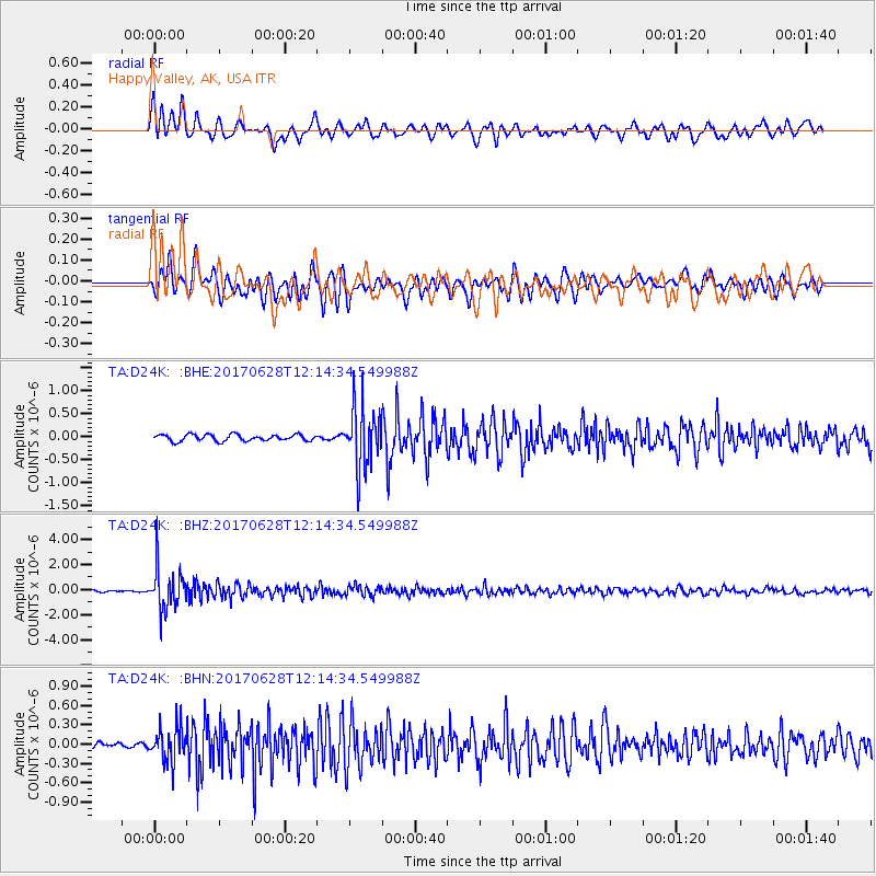
D24K Happy Valley, AK, USA - Earthquake Result Viewer
| Earthquake location: |
Kuril Islands |
| Earthquake latitude/longitude: |
43.7/148.0 |
| Earthquake time(UTC): |
2017/06/28 (179) 12:07:30 GMT |
| Earthquake Depth: |
49 km |
| Earthquake Magnitude: |
5.4 Mww |
| Earthquake Catalog/Contributor: |
NEIC PDE/us |
|
| Network: |
TA USArray Transportable Network (new EarthScope stations) |
| Station: |
D24K Happy Valley, AK, USA |
| Lat/Lon: |
69.15 N/148.82 W |
| Elevation: |
292 m |
|
| Distance: |
40.5 deg |
| Az: |
29.45 deg |
| Baz: |
264.815 deg |
| Ray Param: |
0.074219614 |
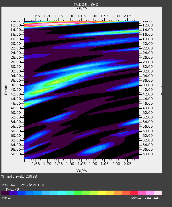
| Estimated Moho Depth: |
11.25 km |
| Estimated Crust Vp/Vs: |
1.76 |
| Assumed Crust Vp: |
6.316 km/s |
| Estimated Crust Vs: |
3.589 km/s |
| Estimated Crust Poisson's Ratio: |
0.26 |
|
| Radial Match: |
81.23938 % |
| Radial Bump: |
400 |
| Transverse Match: |
81.576035 % |
| Transverse Bump: |
400 |
| SOD ConfigId: |
13570011 |
| Insert Time: |
2019-04-28 07:12:53.286 +0000 |
| GWidth: |
2.5 |
| Max Bumps: |
400 |
| Tol: |
0.001 |
|
Signal To Noise
| Channel | StoN | STA | LTA |
| TA:D24K: :BHZ:20170628T12:14:34.549988Z | 26.58743 | 1.650681E-6 | 6.208502E-8 |
| TA:D24K: :BHN:20170628T12:14:34.549988Z | 6.3398423 | 2.6122058E-7 | 4.1203005E-8 |
| TA:D24K: :BHE:20170628T12:14:34.549988Z | 9.749969 | 6.703067E-7 | 6.874963E-8 |
| Arrivals |
| Ps | 1.4 SECOND |
| PpPs | 4.6 SECOND |
| PsPs/PpSs | 6.0 SECOND |


