You are here: Home > Network List > TA - USArray Transportable Network (new EarthScope stations) Stations List
> Station G26K Porcupine River, AK, USA > Earthquake Result Viewer
G26K Porcupine River, AK, USA - Earthquake Result Viewer
| Earthquake location: |
Kuril Islands |
| Earthquake latitude/longitude: |
43.7/148.0 |
| Earthquake time(UTC): |
2017/06/28 (179) 12:07:30 GMT |
| Earthquake Depth: |
49 km |
| Earthquake Magnitude: |
5.4 Mww |
| Earthquake Catalog/Contributor: |
NEIC PDE/us |
|
| Network: |
TA USArray Transportable Network (new EarthScope stations) |
| Station: |
G26K Porcupine River, AK, USA |
| Lat/Lon: |
66.95 N/143.78 W |
| Elevation: |
180 m |
|
| Distance: |
42.4 deg |
| Az: |
32.868 deg |
| Baz: |
272.049 deg |
| Ray Param: |
0.073096015 |
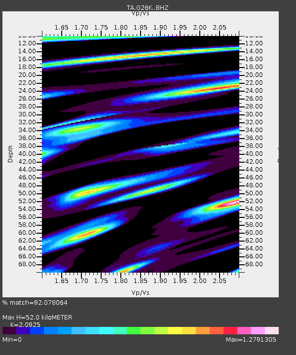
| Estimated Moho Depth: |
52.0 km |
| Estimated Crust Vp/Vs: |
2.09 |
| Assumed Crust Vp: |
6.577 km/s |
| Estimated Crust Vs: |
3.143 km/s |
| Estimated Crust Poisson's Ratio: |
0.35 |
|
| Radial Match: |
92.078064 % |
| Radial Bump: |
400 |
| Transverse Match: |
91.94295 % |
| Transverse Bump: |
400 |
| SOD ConfigId: |
13570011 |
| Insert Time: |
2019-04-28 07:13:11.438 +0000 |
| GWidth: |
2.5 |
| Max Bumps: |
400 |
| Tol: |
0.001 |
|

Signal To Noise
| Channel | StoN | STA | LTA |
| TA:G26K: :BHZ:20170628T12:14:49.600006Z | 20.249758 | 1.3207967E-6 | 6.5225315E-8 |
| TA:G26K: :BHN:20170628T12:14:49.600006Z | 10.896421 | 8.245794E-7 | 7.567433E-8 |
| TA:G26K: :BHE:20170628T12:14:49.600006Z | 15.102082 | 9.345619E-7 | 6.1882986E-8 |
| Arrivals |
| Ps | 9.2 SECOND |
| PpPs | 23 SECOND |
| PsPs/PpSs | 32 SECOND |


