You are here: Home > Network List > TA - USArray Transportable Network (new EarthScope stations) Stations List
> Station H19K Roundabout Mountain, AK, USA > Earthquake Result Viewer
H19K Roundabout Mountain, AK, USA - Earthquake Result Viewer
| Earthquake location: |
Kuril Islands |
| Earthquake latitude/longitude: |
43.7/148.0 |
| Earthquake time(UTC): |
2017/06/28 (179) 12:07:30 GMT |
| Earthquake Depth: |
49 km |
| Earthquake Magnitude: |
5.4 Mww |
| Earthquake Catalog/Contributor: |
NEIC PDE/us |
|
| Network: |
TA USArray Transportable Network (new EarthScope stations) |
| Station: |
H19K Roundabout Mountain, AK, USA |
| Lat/Lon: |
65.53 N/156.45 W |
| Elevation: |
107 m |
|
| Distance: |
37.2 deg |
| Az: |
34.658 deg |
| Baz: |
261.839 deg |
| Ray Param: |
0.07615911 |
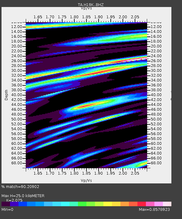
| Estimated Moho Depth: |
25.0 km |
| Estimated Crust Vp/Vs: |
2.08 |
| Assumed Crust Vp: |
6.182 km/s |
| Estimated Crust Vs: |
2.979 km/s |
| Estimated Crust Poisson's Ratio: |
0.35 |
|
| Radial Match: |
90.20902 % |
| Radial Bump: |
400 |
| Transverse Match: |
81.58908 % |
| Transverse Bump: |
400 |
| SOD ConfigId: |
13570011 |
| Insert Time: |
2019-04-28 07:13:18.827 +0000 |
| GWidth: |
2.5 |
| Max Bumps: |
400 |
| Tol: |
0.001 |
|

Signal To Noise
| Channel | StoN | STA | LTA |
| TA:H19K: :BHZ:20170628T12:14:06.600006Z | 44.390984 | 2.172221E-6 | 4.8933835E-8 |
| TA:H19K: :BHN:20170628T12:14:06.600006Z | 7.771748 | 4.2258984E-7 | 5.4375132E-8 |
| TA:H19K: :BHE:20170628T12:14:06.600006Z | 19.367785 | 1.1079345E-6 | 5.720502E-8 |
| Arrivals |
| Ps | 4.6 SECOND |
| PpPs | 12 SECOND |
| PsPs/PpSs | 16 SECOND |


