You are here: Home > Network List > TA - USArray Transportable Network (new EarthScope stations) Stations List
> Station Z19A T-Link Ranch, Clifton, AZ, USA > Earthquake Result Viewer
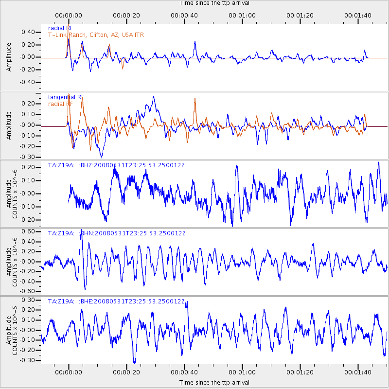
Z19A T-Link Ranch, Clifton, AZ, USA - Earthquake Result Viewer
*The percent match for this event was below the threshold and hence no stack was calculated.
| Earthquake location: |
Easter Island Region |
| Earthquake latitude/longitude: |
-28.9/-112.3 |
| Earthquake time(UTC): |
2008/05/31 (152) 23:16:04 GMT |
| Earthquake Depth: |
10 km |
| Earthquake Magnitude: |
5.5 MS, 5.4 MB, 5.8 MW, 5.8 MW |
| Earthquake Catalog/Contributor: |
WHDF/NEIC |
|
| Network: |
TA USArray Transportable Network (new EarthScope stations) |
| Station: |
Z19A T-Link Ranch, Clifton, AZ, USA |
| Lat/Lon: |
33.29 N/109.27 W |
| Elevation: |
1397 m |
|
| Distance: |
61.9 deg |
| Az: |
2.84 deg |
| Baz: |
182.973 deg |
| Ray Param: |
$rayparam |
*The percent match for this event was below the threshold and hence was not used in the summary stack. |
|
| Radial Match: |
75.31635 % |
| Radial Bump: |
400 |
| Transverse Match: |
57.285324 % |
| Transverse Bump: |
400 |
| SOD ConfigId: |
2504 |
| Insert Time: |
2010-03-06 01:24:33.512 +0000 |
| GWidth: |
2.5 |
| Max Bumps: |
400 |
| Tol: |
0.001 |
|
Signal To Noise
| Channel | StoN | STA | LTA |
| TA:Z19A: :BHN:20080531T23:25:53.250012Z | 3.3320892 | 2.581401E-7 | 7.747095E-8 |
| TA:Z19A: :BHE:20080531T23:25:53.250012Z | 2.1706111 | 9.8644435E-8 | 4.544546E-8 |
| TA:Z19A: :BHZ:20080531T23:25:53.250012Z | 0.44159818 | 4.035945E-8 | 9.139406E-8 |
| Arrivals |
| Ps | |
| PpPs | |
| PsPs/PpSs | |


