You are here: Home > Network List > TA - USArray Transportable Network (new EarthScope stations) Stations List
> Station R33M Jennings River, BC, CAN > Earthquake Result Viewer
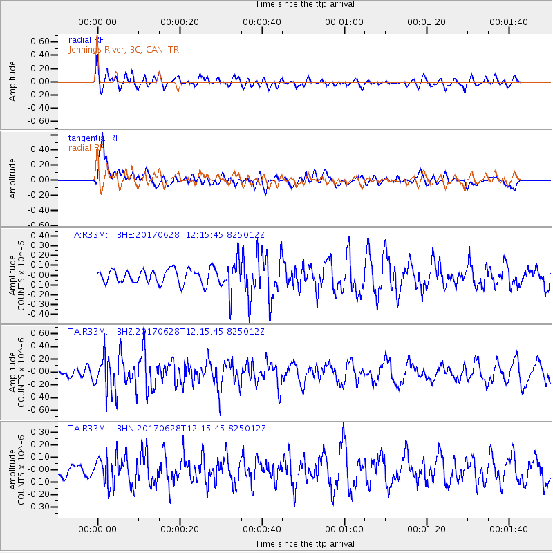
R33M Jennings River, BC, CAN - Earthquake Result Viewer
*The percent match for this event was below the threshold and hence no stack was calculated.
| Earthquake location: |
Kuril Islands |
| Earthquake latitude/longitude: |
43.7/148.0 |
| Earthquake time(UTC): |
2017/06/28 (179) 12:07:30 GMT |
| Earthquake Depth: |
49 km |
| Earthquake Magnitude: |
5.4 Mww |
| Earthquake Catalog/Contributor: |
NEIC PDE/us |
|
| Network: |
TA USArray Transportable Network (new EarthScope stations) |
| Station: |
R33M Jennings River, BC, CAN |
| Lat/Lon: |
59.39 N/130.97 W |
| Elevation: |
1437 m |
|
| Distance: |
49.5 deg |
| Az: |
41.653 deg |
| Baz: |
289.633 deg |
| Ray Param: |
$rayparam |
*The percent match for this event was below the threshold and hence was not used in the summary stack. |
|
| Radial Match: |
51.6401 % |
| Radial Bump: |
400 |
| Transverse Match: |
71.72867 % |
| Transverse Bump: |
400 |
| SOD ConfigId: |
13570011 |
| Insert Time: |
2019-04-28 07:14:42.331 +0000 |
| GWidth: |
2.5 |
| Max Bumps: |
400 |
| Tol: |
0.001 |
|
Signal To Noise
| Channel | StoN | STA | LTA |
| TA:R33M: :BHZ:20170628T12:15:45.825012Z | 5.723787 | 2.844415E-7 | 4.969464E-8 |
| TA:R33M: :BHN:20170628T12:15:45.825012Z | 2.8850152 | 1.16455965E-7 | 4.036581E-8 |
| TA:R33M: :BHE:20170628T12:15:45.825012Z | 2.3636465 | 1.5305595E-7 | 6.475416E-8 |
| Arrivals |
| Ps | |
| PpPs | |
| PsPs/PpSs | |


