You are here: Home > Network List > TA - USArray Transportable Network (new EarthScope stations) Stations List
> Station R32K Eaglecrest, AK, USA > Earthquake Result Viewer
R32K Eaglecrest, AK, USA - Earthquake Result Viewer
*The percent match for this event was below the threshold and hence no stack was calculated.
| Earthquake location: |
Kuril Islands |
| Earthquake latitude/longitude: |
43.7/148.0 |
| Earthquake time(UTC): |
2017/06/28 (179) 12:07:30 GMT |
| Earthquake Depth: |
49 km |
| Earthquake Magnitude: |
5.4 Mww |
| Earthquake Catalog/Contributor: |
NEIC PDE/us |
|
| Network: |
TA USArray Transportable Network (new EarthScope stations) |
| Station: |
R32K Eaglecrest, AK, USA |
| Lat/Lon: |
58.27 N/134.52 W |
| Elevation: |
386 m |
|
| Distance: |
48.1 deg |
| Az: |
43.858 deg |
| Baz: |
288.052 deg |
| Ray Param: |
$rayparam |
*The percent match for this event was below the threshold and hence was not used in the summary stack. |
|
| Radial Match: |
38.811558 % |
| Radial Bump: |
400 |
| Transverse Match: |
71.590904 % |
| Transverse Bump: |
400 |
| SOD ConfigId: |
13570011 |
| Insert Time: |
2019-04-28 07:14:42.600 +0000 |
| GWidth: |
2.5 |
| Max Bumps: |
400 |
| Tol: |
0.001 |
|
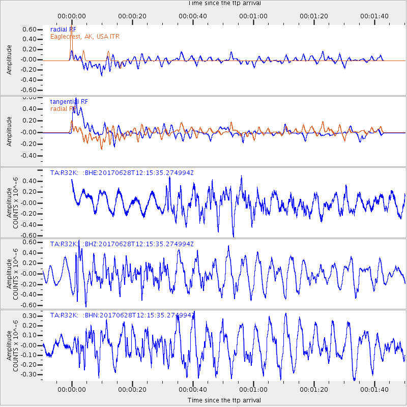
Signal To Noise
| Channel | StoN | STA | LTA |
| TA:R32K: :BHZ:20170628T12:15:35.274994Z | 2.35154 | 3.4658794E-7 | 1.4738764E-7 |
| TA:R32K: :BHN:20170628T12:15:35.274994Z | 0.6272085 | 8.7286466E-8 | 1.391666E-7 |
| TA:R32K: :BHE:20170628T12:15:35.274994Z | 1.4520793 | 2.1187721E-7 | 1.4591298E-7 |
| Arrivals |
| Ps | |
| PpPs | |
| PsPs/PpSs | |


