You are here: Home > Network List > CB - China National Seismic Network Stations List
> Station WHN Wuhantai,Hubei Province > Earthquake Result Viewer
WHN Wuhantai,Hubei Province - Earthquake Result Viewer
| Earthquake location: |
Kermadec Islands, New Zealand |
| Earthquake latitude/longitude: |
-30.4/-177.7 |
| Earthquake time(UTC): |
2017/06/28 (179) 18:20:53 GMT |
| Earthquake Depth: |
10 km |
| Earthquake Magnitude: |
6.0 Mwb |
| Earthquake Catalog/Contributor: |
NEIC PDE/us |
|
| Network: |
CB China National Seismic Network |
| Station: |
WHN Wuhantai,Hubei Province |
| Lat/Lon: |
30.54 N/114.35 E |
| Elevation: |
80 m |
|
| Distance: |
88.6 deg |
| Az: |
306.868 deg |
| Baz: |
126.772 deg |
| Ray Param: |
0.04247867 |
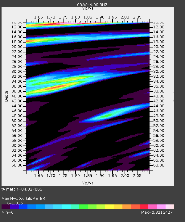
| Estimated Moho Depth: |
10.0 km |
| Estimated Crust Vp/Vs: |
1.82 |
| Assumed Crust Vp: |
6.276 km/s |
| Estimated Crust Vs: |
3.458 km/s |
| Estimated Crust Poisson's Ratio: |
0.28 |
|
| Radial Match: |
84.827065 % |
| Radial Bump: |
345 |
| Transverse Match: |
73.17684 % |
| Transverse Bump: |
400 |
| SOD ConfigId: |
13570011 |
| Insert Time: |
2019-04-28 07:18:12.197 +0000 |
| GWidth: |
2.5 |
| Max Bumps: |
400 |
| Tol: |
0.001 |
|

Signal To Noise
| Channel | StoN | STA | LTA |
| CB:WHN:00:BHZ:20170628T18:33:15.180Z | 4.069635 | 4.3523863E-7 | 1.0694784E-7 |
| CB:WHN:00:BHN:20170628T18:33:15.180Z | 1.0789994 | 1.5130105E-7 | 1.4022348E-7 |
| CB:WHN:00:BHE:20170628T18:33:15.180Z | 1.165733 | 1.4811927E-7 | 1.2706106E-7 |
| Arrivals |
| Ps | 1.3 SECOND |
| PpPs | 4.4 SECOND |
| PsPs/PpSs | 5.7 SECOND |


