You are here: Home > Network List > TA - USArray Transportable Network (new EarthScope stations) Stations List
> Station W22A Albuquerque, NM, USA > Earthquake Result Viewer
W22A Albuquerque, NM, USA - Earthquake Result Viewer

| Earthquake location: |
Santa Cruz Islands Region |
| Earthquake latitude/longitude: |
-11.0/164.5 |
| Earthquake time(UTC): |
2008/07/19 (201) 09:27:01 GMT |
| Earthquake Depth: |
11 km |
| Earthquake Magnitude: |
6.1 MB, 6.4 MS, 6.6 MW, 6.6 MW |
| Earthquake Catalog/Contributor: |
WHDF/NEIC |
|
| Network: |
TA USArray Transportable Network (new EarthScope stations) |
| Station: |
W22A Albuquerque, NM, USA |
| Lat/Lon: |
35.07 N/106.87 W |
| Elevation: |
1813 m |
|
| Distance: |
95.1 deg |
| Az: |
55.42 deg |
| Baz: |
260.207 deg |
| Ray Param: |
0.040858846 |
| Estimated Moho Depth: |
12.0 km |
| Estimated Crust Vp/Vs: |
1.66 |
| Assumed Crust Vp: |
6.502 km/s |
| Estimated Crust Vs: |
3.917 km/s |
| Estimated Crust Poisson's Ratio: |
0.22 |
|
| Radial Match: |
82.158936 % |
| Radial Bump: |
376 |
| Transverse Match: |
68.896935 % |
| Transverse Bump: |
398 |
| SOD ConfigId: |
2658 |
| Insert Time: |
2010-03-06 01:25:42.331 +0000 |
| GWidth: |
2.5 |
| Max Bumps: |
400 |
| Tol: |
0.001 |
|
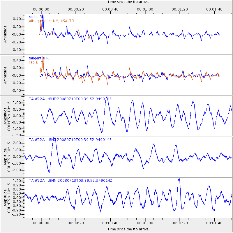
Signal To Noise
| Channel | StoN | STA | LTA |
| TA:W22A: :BHZ:20080719T09:39:52.949014Z | 6.4851804 | 9.647891E-7 | 1.4876828E-7 |
| TA:W22A: :BHN:20080719T09:39:52.949014Z | 0.3436649 | 1.18890476E-7 | 3.4594882E-7 |
| TA:W22A: :BHE:20080719T09:39:52.949014Z | 1.6952295 | 5.527793E-7 | 3.2607934E-7 |
| Arrivals |
| Ps | 1.2 SECOND |
| PpPs | 4.8 SECOND |
| PsPs/PpSs | 6.0 SECOND |


