You are here: Home > Network List > TA - USArray Transportable Network (new EarthScope stations) Stations List
> Station W22A Albuquerque, NM, USA > Earthquake Result Viewer
W22A Albuquerque, NM, USA - Earthquake Result Viewer
| Earthquake location: |
Kermadec Islands Region |
| Earthquake latitude/longitude: |
-27.4/-176.3 |
| Earthquake time(UTC): |
2009/02/18 (049) 21:53:45 GMT |
| Earthquake Depth: |
25 km |
| Earthquake Magnitude: |
6.8 MB, 7.2 MS, 6.9 MW, 6.9 MW |
| Earthquake Catalog/Contributor: |
WHDF/NEIC |
|
| Network: |
TA USArray Transportable Network (new EarthScope stations) |
| Station: |
W22A Albuquerque, NM, USA |
| Lat/Lon: |
35.07 N/106.87 W |
| Elevation: |
1813 m |
|
| Distance: |
90.4 deg |
| Az: |
50.186 deg |
| Baz: |
236.346 deg |
| Ray Param: |
0.041676424 |
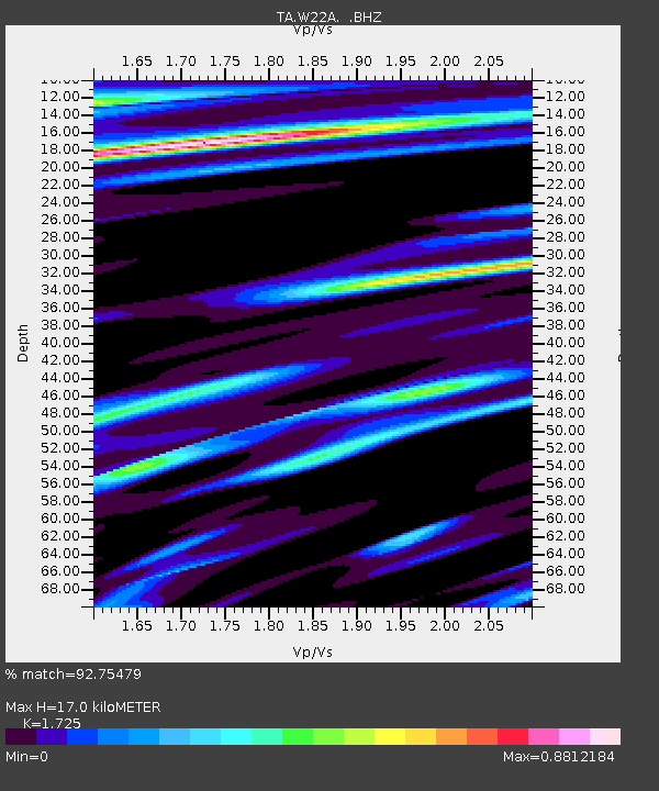
| Estimated Moho Depth: |
17.0 km |
| Estimated Crust Vp/Vs: |
1.73 |
| Assumed Crust Vp: |
6.502 km/s |
| Estimated Crust Vs: |
3.769 km/s |
| Estimated Crust Poisson's Ratio: |
0.25 |
|
| Radial Match: |
92.75479 % |
| Radial Bump: |
385 |
| Transverse Match: |
87.49992 % |
| Transverse Bump: |
249 |
| SOD ConfigId: |
2658 |
| Insert Time: |
2010-03-06 01:25:44.518 +0000 |
| GWidth: |
2.5 |
| Max Bumps: |
400 |
| Tol: |
0.001 |
|
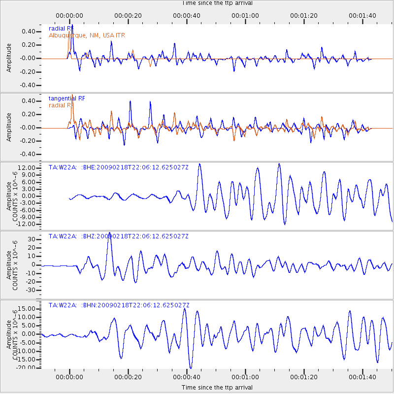
Signal To Noise
| Channel | StoN | STA | LTA |
| TA:W22A: :BHZ:20090218T22:06:12.625027Z | 7.892159 | 3.338799E-6 | 4.2305268E-7 |
| TA:W22A: :BHN:20090218T22:06:12.625027Z | 0.92232376 | 7.187257E-7 | 7.7925534E-7 |
| TA:W22A: :BHE:20090218T22:06:12.625027Z | 1.3645749 | 1.0400009E-6 | 7.6214275E-7 |
| Arrivals |
| Ps | 1.9 SECOND |
| PpPs | 7.0 SECOND |
| PsPs/PpSs | 8.9 SECOND |


