You are here: Home > Network List > TA - USArray Transportable Network (new EarthScope stations) Stations List
> Station W22A Albuquerque, NM, USA > Earthquake Result Viewer
W22A Albuquerque, NM, USA - Earthquake Result Viewer

| Earthquake location: |
Tonga Islands Region |
| Earthquake latitude/longitude: |
-23.0/-174.7 |
| Earthquake time(UTC): |
2009/03/19 (078) 18:17:40 GMT |
| Earthquake Depth: |
34 km |
| Earthquake Magnitude: |
7.0 MB, 7.6 MS, 7.6 MW, 7.6 MW |
| Earthquake Catalog/Contributor: |
WHDF/NEIC |
|
| Network: |
TA USArray Transportable Network (new EarthScope stations) |
| Station: |
W22A Albuquerque, NM, USA |
| Lat/Lon: |
35.07 N/106.87 W |
| Elevation: |
1813 m |
|
| Distance: |
86.4 deg |
| Az: |
49.544 deg |
| Baz: |
238.704 deg |
| Ray Param: |
0.044040553 |
| Estimated Moho Depth: |
11.25 km |
| Estimated Crust Vp/Vs: |
1.61 |
| Assumed Crust Vp: |
6.502 km/s |
| Estimated Crust Vs: |
4.038 km/s |
| Estimated Crust Poisson's Ratio: |
0.19 |
|
| Radial Match: |
92.072464 % |
| Radial Bump: |
400 |
| Transverse Match: |
90.90499 % |
| Transverse Bump: |
400 |
| SOD ConfigId: |
2658 |
| Insert Time: |
2010-03-06 01:25:50.061 +0000 |
| GWidth: |
2.5 |
| Max Bumps: |
400 |
| Tol: |
0.001 |
|
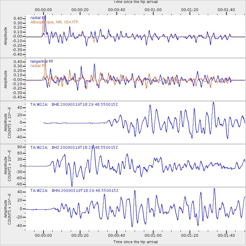
Signal To Noise
| Channel | StoN | STA | LTA |
| TA:W22A: :BHZ:20090319T18:29:48.550015Z | 27.075716 | 7.0682977E-6 | 2.6105673E-7 |
| TA:W22A: :BHN:20090319T18:29:48.550015Z | 1.3522106 | 5.9081947E-7 | 4.369286E-7 |
| TA:W22A: :BHE:20090319T18:29:48.550015Z | 1.876181 | 7.2247605E-7 | 3.85078E-7 |
| Arrivals |
| Ps | 1.1 SECOND |
| PpPs | 4.4 SECOND |
| PsPs/PpSs | 5.5 SECOND |


