You are here: Home > Network List > TA - USArray Transportable Network (new EarthScope stations) Stations List
> Station R11B Troy Canyon, Currant, NV, USA > Earthquake Result Viewer
R11B Troy Canyon, Currant, NV, USA - Earthquake Result Viewer
| Earthquake location: |
Kermadec Islands, New Zealand |
| Earthquake latitude/longitude: |
-30.4/-177.7 |
| Earthquake time(UTC): |
2017/06/28 (179) 18:20:53 GMT |
| Earthquake Depth: |
10 km |
| Earthquake Magnitude: |
6.0 Mwb |
| Earthquake Catalog/Contributor: |
NEIC PDE/us |
|
| Network: |
TA USArray Transportable Network (new EarthScope stations) |
| Station: |
R11B Troy Canyon, Currant, NV, USA |
| Lat/Lon: |
38.35 N/115.59 W |
| Elevation: |
1767 m |
|
| Distance: |
89.6 deg |
| Az: |
44.011 deg |
| Baz: |
229.759 deg |
| Ray Param: |
0.04173192 |
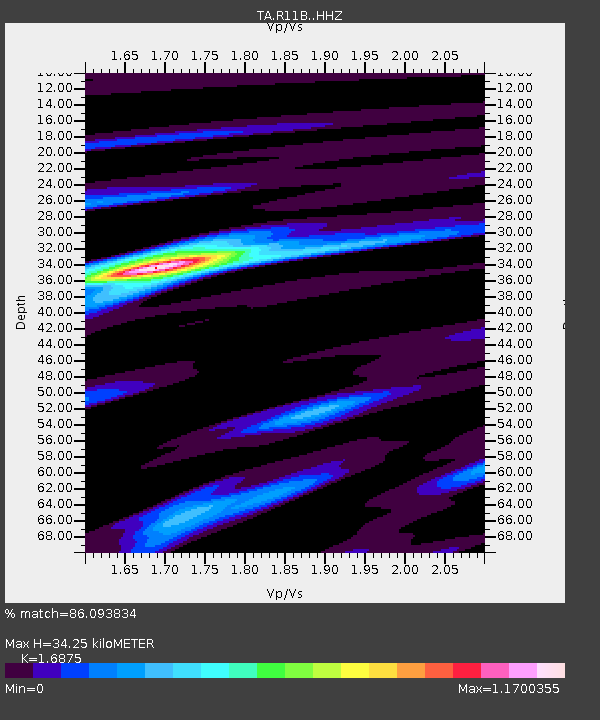
| Estimated Moho Depth: |
34.25 km |
| Estimated Crust Vp/Vs: |
1.69 |
| Assumed Crust Vp: |
6.276 km/s |
| Estimated Crust Vs: |
3.719 km/s |
| Estimated Crust Poisson's Ratio: |
0.23 |
|
| Radial Match: |
86.093834 % |
| Radial Bump: |
379 |
| Transverse Match: |
61.255974 % |
| Transverse Bump: |
400 |
| SOD ConfigId: |
13570011 |
| Insert Time: |
2019-04-28 07:22:01.027 +0000 |
| GWidth: |
2.5 |
| Max Bumps: |
400 |
| Tol: |
0.001 |
|

Signal To Noise
| Channel | StoN | STA | LTA |
| TA:R11B: :HHZ:20170628T18:33:19.90998Z | 3.794897 | 1.66494E-7 | 4.387313E-8 |
| TA:R11B: :HHN:20170628T18:33:19.90998Z | 0.57907546 | 2.6114886E-8 | 4.5097554E-8 |
| TA:R11B: :HHE:20170628T18:33:19.90998Z | 2.0475805 | 6.32803E-8 | 3.0904914E-8 |
| Arrivals |
| Ps | 3.8 SECOND |
| PpPs | 14 SECOND |
| PsPs/PpSs | 18 SECOND |


