You are here: Home > Network List > TA - USArray Transportable Network (new EarthScope stations) Stations List
> Station R17K Ugashik Creek, AK, USA > Earthquake Result Viewer
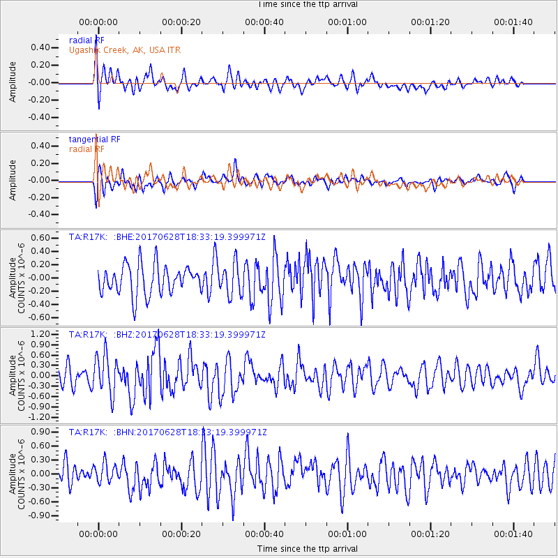
R17K Ugashik Creek, AK, USA - Earthquake Result Viewer
*The percent match for this event was below the threshold and hence no stack was calculated.
| Earthquake location: |
Kermadec Islands, New Zealand |
| Earthquake latitude/longitude: |
-30.4/-177.7 |
| Earthquake time(UTC): |
2017/06/28 (179) 18:20:53 GMT |
| Earthquake Depth: |
10 km |
| Earthquake Magnitude: |
6.0 Mwb |
| Earthquake Catalog/Contributor: |
NEIC PDE/us |
|
| Network: |
TA USArray Transportable Network (new EarthScope stations) |
| Station: |
R17K Ugashik Creek, AK, USA |
| Lat/Lon: |
57.64 N/156.39 W |
| Elevation: |
273 m |
|
| Distance: |
89.5 deg |
| Az: |
11.258 deg |
| Baz: |
198.274 deg |
| Ray Param: |
$rayparam |
*The percent match for this event was below the threshold and hence was not used in the summary stack. |
|
| Radial Match: |
68.284615 % |
| Radial Bump: |
400 |
| Transverse Match: |
65.04907 % |
| Transverse Bump: |
400 |
| SOD ConfigId: |
13570011 |
| Insert Time: |
2019-04-28 07:22:03.307 +0000 |
| GWidth: |
2.5 |
| Max Bumps: |
400 |
| Tol: |
0.001 |
|
Signal To Noise
| Channel | StoN | STA | LTA |
| TA:R17K: :BHZ:20170628T18:33:19.399971Z | 2.0137346 | 5.850574E-7 | 2.9053354E-7 |
| TA:R17K: :BHN:20170628T18:33:19.399971Z | 0.72736394 | 2.0300234E-7 | 2.7909323E-7 |
| TA:R17K: :BHE:20170628T18:33:19.399971Z | 1.094745 | 2.4154045E-7 | 2.2063625E-7 |
| Arrivals |
| Ps | |
| PpPs | |
| PsPs/PpSs | |


