You are here: Home > Network List > TA - USArray Transportable Network (new EarthScope stations) Stations List
> Station R11A Troy Canyon, Currant, NV, USA > Earthquake Result Viewer
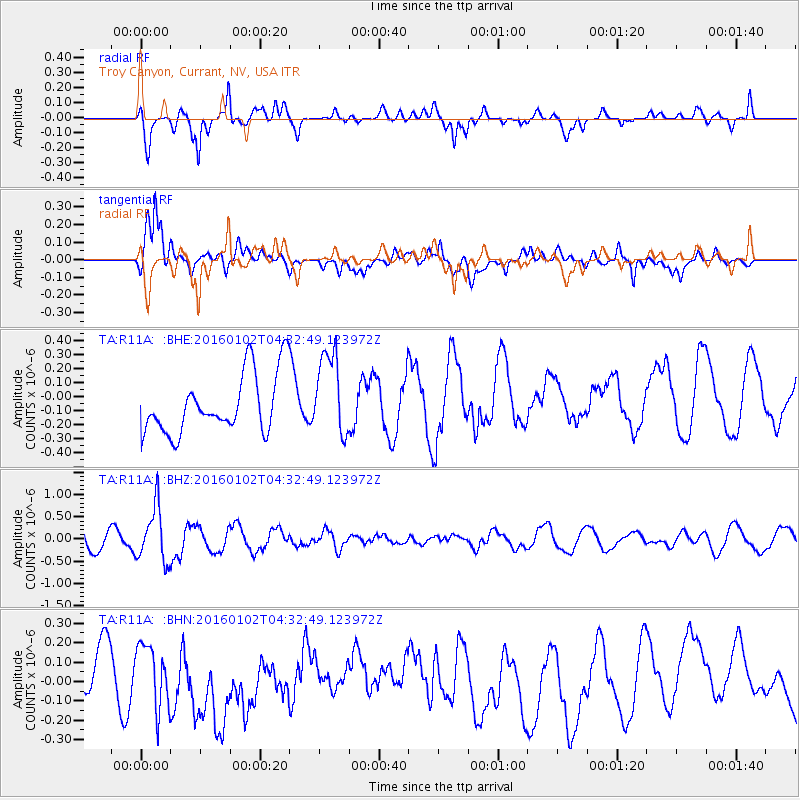
R11A Troy Canyon, Currant, NV, USA - Earthquake Result Viewer
*The percent match for this event was below the threshold and hence no stack was calculated.
| Earthquake location: |
Northeastern China |
| Earthquake latitude/longitude: |
44.9/130.0 |
| Earthquake time(UTC): |
2016/01/02 (002) 04:22:19 GMT |
| Earthquake Depth: |
583 km |
| Earthquake Magnitude: |
5.7 MWP |
| Earthquake Catalog/Contributor: |
NEIC PDE/NEIC COMCAT |
|
| Network: |
TA USArray Transportable Network (new EarthScope stations) |
| Station: |
R11A Troy Canyon, Currant, NV, USA |
| Lat/Lon: |
38.35 N/115.59 W |
| Elevation: |
1756 m |
|
| Distance: |
78.3 deg |
| Az: |
46.971 deg |
| Baz: |
318.613 deg |
| Ray Param: |
$rayparam |
*The percent match for this event was below the threshold and hence was not used in the summary stack. |
|
| Radial Match: |
47.759228 % |
| Radial Bump: |
376 |
| Transverse Match: |
57.59497 % |
| Transverse Bump: |
400 |
| SOD ConfigId: |
1379111 |
| Insert Time: |
2016-01-16 05:32:32.394 +0000 |
| GWidth: |
2.5 |
| Max Bumps: |
400 |
| Tol: |
0.001 |
|
Signal To Noise
| Channel | StoN | STA | LTA |
| TA:R11A: :BHZ:20160102T04:32:49.123972Z | 3.4034574 | 6.1180054E-7 | 1.7975854E-7 |
| TA:R11A: :BHN:20160102T04:32:49.123972Z | 1.6558458 | 1.7875252E-7 | 1.07952395E-7 |
| TA:R11A: :BHE:20160102T04:32:49.123972Z | 1.4269991 | 2.9956385E-7 | 2.0992574E-7 |
| Arrivals |
| Ps | |
| PpPs | |
| PsPs/PpSs | |


