You are here: Home > Network List > TA - USArray Transportable Network (new EarthScope stations) Stations List
> Station W22A Albuquerque, NM, USA > Earthquake Result Viewer
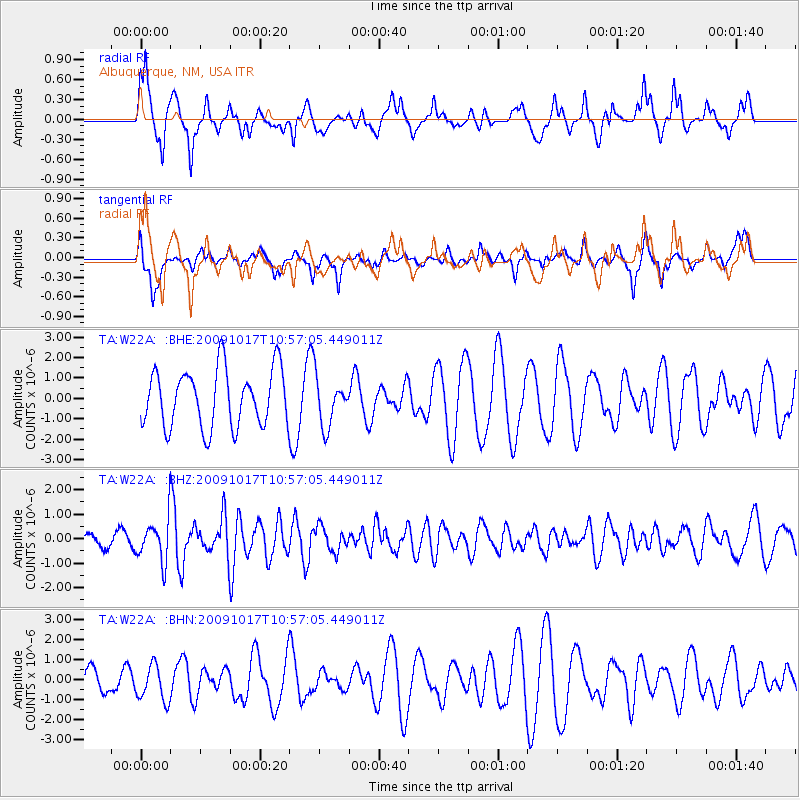
W22A Albuquerque, NM, USA - Earthquake Result Viewer
*The percent match for this event was below the threshold and hence no stack was calculated.
| Earthquake location: |
Samoa Islands Region |
| Earthquake latitude/longitude: |
-16.4/-172.0 |
| Earthquake time(UTC): |
2009/10/17 (290) 10:45:26 GMT |
| Earthquake Depth: |
10 km |
| Earthquake Magnitude: |
5.7 MB, 5.3 MS, 5.7 MW, 5.7 MW |
| Earthquake Catalog/Contributor: |
WHDF/NEIC |
|
| Network: |
TA USArray Transportable Network (new EarthScope stations) |
| Station: |
W22A Albuquerque, NM, USA |
| Lat/Lon: |
35.07 N/106.87 W |
| Elevation: |
1813 m |
|
| Distance: |
80.1 deg |
| Az: |
49.047 deg |
| Baz: |
242.12 deg |
| Ray Param: |
$rayparam |
*The percent match for this event was below the threshold and hence was not used in the summary stack. |
|
| Radial Match: |
62.97996 % |
| Radial Bump: |
396 |
| Transverse Match: |
62.128998 % |
| Transverse Bump: |
395 |
| SOD ConfigId: |
2622 |
| Insert Time: |
2010-03-06 01:27:14.478 +0000 |
| GWidth: |
2.5 |
| Max Bumps: |
400 |
| Tol: |
0.001 |
|
Signal To Noise
| Channel | StoN | STA | LTA |
| TA:W22A: :BHZ:20091017T10:57:05.449011Z | 3.032311 | 8.516554E-7 | 2.8086018E-7 |
| TA:W22A: :BHN:20091017T10:57:05.449011Z | 1.8124876 | 8.985591E-7 | 4.9576016E-7 |
| TA:W22A: :BHE:20091017T10:57:05.449011Z | 0.82849985 | 1.1679974E-6 | 1.4097737E-6 |
| Arrivals |
| Ps | |
| PpPs | |
| PsPs/PpSs | |


