You are here: Home > Network List > CN - Canadian National Seismograph Network Stations List
> Station INK INUVIK, NT > Earthquake Result Viewer
INK INUVIK, NT - Earthquake Result Viewer
*The percent match for this event was below the threshold and hence no stack was calculated.
| Earthquake location: |
Northern Mid-Atlantic Ridge |
| Earthquake latitude/longitude: |
33.7/-38.5 |
| Earthquake time(UTC): |
2017/06/30 (181) 01:34:58 GMT |
| Earthquake Depth: |
10 km |
| Earthquake Magnitude: |
5.8 Mwb |
| Earthquake Catalog/Contributor: |
NEIC PDE/us |
|
| Network: |
CN Canadian National Seismograph Network |
| Station: |
INK INUVIK, NT |
| Lat/Lon: |
68.31 N/133.53 W |
| Elevation: |
44 m |
|
| Distance: |
60.9 deg |
| Az: |
334.917 deg |
| Baz: |
71.813 deg |
| Ray Param: |
$rayparam |
*The percent match for this event was below the threshold and hence was not used in the summary stack. |
|
| Radial Match: |
79.5767 % |
| Radial Bump: |
327 |
| Transverse Match: |
67.62489 % |
| Transverse Bump: |
400 |
| SOD ConfigId: |
13570011 |
| Insert Time: |
2019-04-28 07:30:43.739 +0000 |
| GWidth: |
2.5 |
| Max Bumps: |
400 |
| Tol: |
0.001 |
|
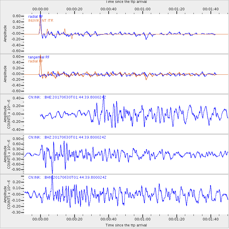
Signal To Noise
| Channel | StoN | STA | LTA |
| CN:INK: :BHZ:20170630T01:44:39.800024Z | 4.537848 | 3.4630213E-7 | 7.631417E-8 |
| CN:INK: :BHN:20170630T01:44:39.800024Z | 1.3635123 | 5.9072907E-8 | 4.3324075E-8 |
| CN:INK: :BHE:20170630T01:44:39.800024Z | 2.8718934 | 1.4520599E-7 | 5.0561066E-8 |
| Arrivals |
| Ps | |
| PpPs | |
| PsPs/PpSs | |


