You are here: Home > Network List > TA - USArray Transportable Network (new EarthScope stations) Stations List
> Station W22A Albuquerque, NM, USA > Earthquake Result Viewer
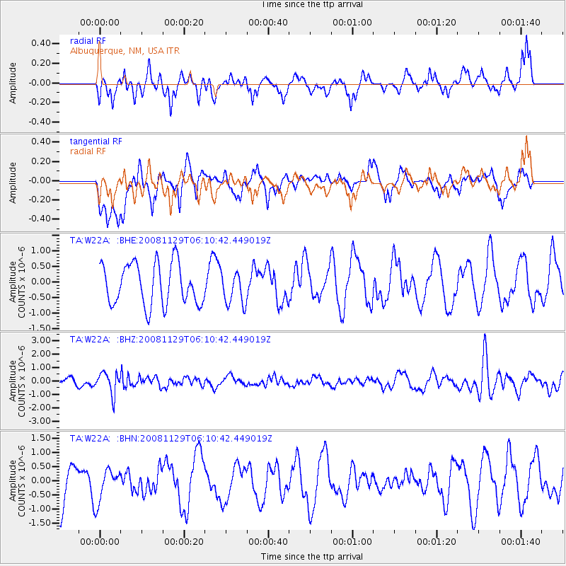
W22A Albuquerque, NM, USA - Earthquake Result Viewer
*The percent match for this event was below the threshold and hence no stack was calculated.
| Earthquake location: |
Fiji Islands Region |
| Earthquake latitude/longitude: |
-18.7/-177.7 |
| Earthquake time(UTC): |
2008/11/29 (334) 05:59:16 GMT |
| Earthquake Depth: |
386 km |
| Earthquake Magnitude: |
5.7 MB, 6.0 MW, 5.9 MW |
| Earthquake Catalog/Contributor: |
WHDF/NEIC |
|
| Network: |
TA USArray Transportable Network (new EarthScope stations) |
| Station: |
W22A Albuquerque, NM, USA |
| Lat/Lon: |
35.07 N/106.87 W |
| Elevation: |
1813 m |
|
| Distance: |
85.8 deg |
| Az: |
50.978 deg |
| Baz: |
243.867 deg |
| Ray Param: |
$rayparam |
*The percent match for this event was below the threshold and hence was not used in the summary stack. |
|
| Radial Match: |
42.534954 % |
| Radial Bump: |
370 |
| Transverse Match: |
45.739136 % |
| Transverse Bump: |
400 |
| SOD ConfigId: |
2658 |
| Insert Time: |
2010-03-06 01:27:30.827 +0000 |
| GWidth: |
2.5 |
| Max Bumps: |
400 |
| Tol: |
0.001 |
|
Signal To Noise
| Channel | StoN | STA | LTA |
| TA:W22A: :BHZ:20081129T06:10:42.449019Z | 3.250856 | 8.1599006E-7 | 2.5100778E-7 |
| TA:W22A: :BHN:20081129T06:10:42.449019Z | 1.0299463 | 5.452403E-7 | 5.293871E-7 |
| TA:W22A: :BHE:20081129T06:10:42.449019Z | 0.7866823 | 5.221335E-7 | 6.6371587E-7 |
| Arrivals |
| Ps | |
| PpPs | |
| PsPs/PpSs | |


