You are here: Home > Network List > N4 - Central and EAstern US Network Stations List
> Station L46A Eue Claire, MI, USA > Earthquake Result Viewer
L46A Eue Claire, MI, USA - Earthquake Result Viewer
| Earthquake location: |
Northern Mid-Atlantic Ridge |
| Earthquake latitude/longitude: |
33.7/-38.5 |
| Earthquake time(UTC): |
2017/06/30 (181) 01:34:58 GMT |
| Earthquake Depth: |
10 km |
| Earthquake Magnitude: |
5.8 Mwb |
| Earthquake Catalog/Contributor: |
NEIC PDE/us |
|
| Network: |
N4 Central and EAstern US Network |
| Station: |
L46A Eue Claire, MI, USA |
| Lat/Lon: |
42.01 N/86.30 W |
| Elevation: |
223 m |
|
| Distance: |
38.2 deg |
| Az: |
296.789 deg |
| Baz: |
86.427 deg |
| Ray Param: |
0.075719334 |
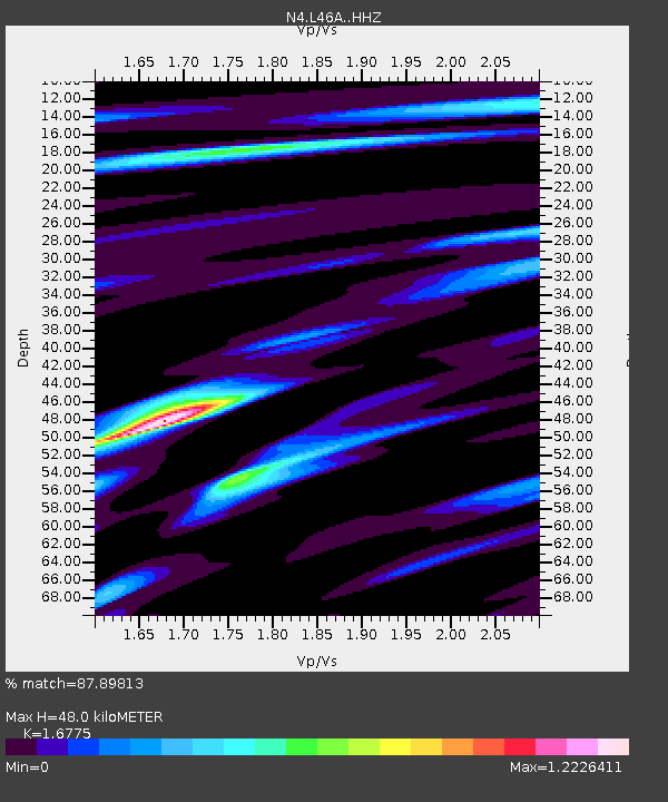
| Estimated Moho Depth: |
48.0 km |
| Estimated Crust Vp/Vs: |
1.68 |
| Assumed Crust Vp: |
6.483 km/s |
| Estimated Crust Vs: |
3.864 km/s |
| Estimated Crust Poisson's Ratio: |
0.22 |
|
| Radial Match: |
87.89813 % |
| Radial Bump: |
316 |
| Transverse Match: |
49.81791 % |
| Transverse Bump: |
400 |
| SOD ConfigId: |
13570011 |
| Insert Time: |
2019-04-28 07:33:04.298 +0000 |
| GWidth: |
2.5 |
| Max Bumps: |
400 |
| Tol: |
0.001 |
|

Signal To Noise
| Channel | StoN | STA | LTA |
| N4:L46A: :HHZ:20170630T01:41:46.780005Z | 2.4577277 | 2.9455077E-7 | 1.1984679E-7 |
| N4:L46A: :HHN:20170630T01:41:46.780005Z | 1.188168 | 1.6220551E-7 | 1.3651731E-7 |
| N4:L46A: :HHE:20170630T01:41:46.780005Z | 1.9090738 | 2.7950549E-7 | 1.4640895E-7 |
| Arrivals |
| Ps | 5.4 SECOND |
| PpPs | 18 SECOND |
| PsPs/PpSs | 24 SECOND |


