You are here: Home > Network List > TA - USArray Transportable Network (new EarthScope stations) Stations List
> Station I23K Minto, Yukon-Koyukuk, AK, USA > Earthquake Result Viewer
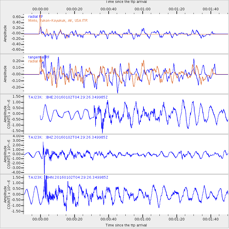
I23K Minto, Yukon-Koyukuk, AK, USA - Earthquake Result Viewer
*The percent match for this event was below the threshold and hence no stack was calculated.
| Earthquake location: |
Northeastern China |
| Earthquake latitude/longitude: |
44.9/130.0 |
| Earthquake time(UTC): |
2016/01/02 (002) 04:22:19 GMT |
| Earthquake Depth: |
583 km |
| Earthquake Magnitude: |
5.7 MWP |
| Earthquake Catalog/Contributor: |
NEIC PDE/NEIC COMCAT |
|
| Network: |
TA USArray Transportable Network (new EarthScope stations) |
| Station: |
I23K Minto, Yukon-Koyukuk, AK, USA |
| Lat/Lon: |
65.15 N/149.36 W |
| Elevation: |
149 m |
|
| Distance: |
46.7 deg |
| Az: |
34.965 deg |
| Baz: |
285.351 deg |
| Ray Param: |
$rayparam |
*The percent match for this event was below the threshold and hence was not used in the summary stack. |
|
| Radial Match: |
27.813768 % |
| Radial Bump: |
379 |
| Transverse Match: |
52.984035 % |
| Transverse Bump: |
400 |
| SOD ConfigId: |
1379111 |
| Insert Time: |
2016-01-16 05:34:22.688 +0000 |
| GWidth: |
2.5 |
| Max Bumps: |
400 |
| Tol: |
0.001 |
|
Signal To Noise
| Channel | StoN | STA | LTA |
| TA:I23K: :BHZ:20160102T04:29:26.349985Z | 5.655745 | 1.0870065E-6 | 1.921951E-7 |
| TA:I23K: :BHN:20160102T04:29:26.349985Z | 1.6062124 | 7.3055327E-7 | 4.548298E-7 |
| TA:I23K: :BHE:20160102T04:29:26.349985Z | 1.2270477 | 4.0746244E-7 | 3.3206732E-7 |
| Arrivals |
| Ps | |
| PpPs | |
| PsPs/PpSs | |


