You are here: Home > Network List > TA - USArray Transportable Network (new EarthScope stations) Stations List
> Station W22A Albuquerque, NM, USA > Earthquake Result Viewer
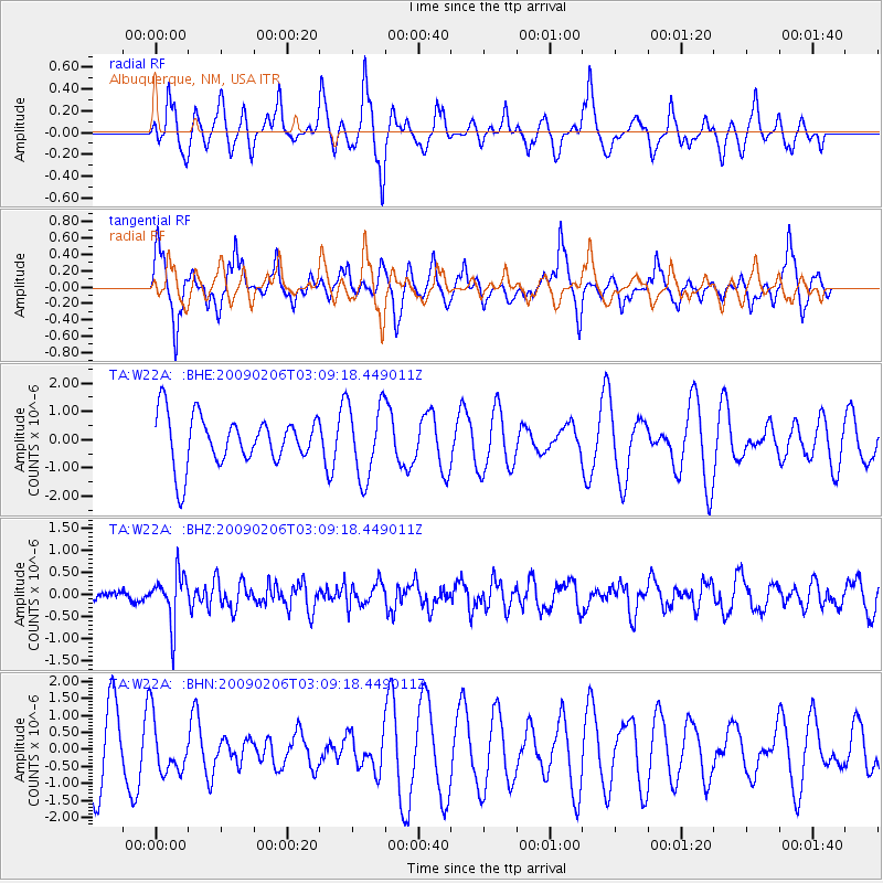
W22A Albuquerque, NM, USA - Earthquake Result Viewer
*The percent match for this event was below the threshold and hence no stack was calculated.
| Earthquake location: |
Near Coast Of Northern Chile |
| Earthquake latitude/longitude: |
-28.0/-71.1 |
| Earthquake time(UTC): |
2009/02/06 (037) 02:58:35 GMT |
| Earthquake Depth: |
52 km |
| Earthquake Magnitude: |
5.5 MB |
| Earthquake Catalog/Contributor: |
WHDF/NEIC |
|
| Network: |
TA USArray Transportable Network (new EarthScope stations) |
| Station: |
W22A Albuquerque, NM, USA |
| Lat/Lon: |
35.07 N/106.87 W |
| Elevation: |
1813 m |
|
| Distance: |
71.2 deg |
| Az: |
329.584 deg |
| Baz: |
146.918 deg |
| Ray Param: |
$rayparam |
*The percent match for this event was below the threshold and hence was not used in the summary stack. |
|
| Radial Match: |
37.90144 % |
| Radial Bump: |
275 |
| Transverse Match: |
46.22056 % |
| Transverse Bump: |
318 |
| SOD ConfigId: |
2658 |
| Insert Time: |
2010-03-06 01:28:19.047 +0000 |
| GWidth: |
2.5 |
| Max Bumps: |
400 |
| Tol: |
0.001 |
|
Signal To Noise
| Channel | StoN | STA | LTA |
| TA:W22A: :BHZ:20090206T03:09:18.449011Z | 2.7179666 | 5.646869E-7 | 2.0776079E-7 |
| TA:W22A: :BHN:20090206T03:09:18.449011Z | 0.9625701 | 7.9401343E-7 | 8.2488896E-7 |
| TA:W22A: :BHE:20090206T03:09:18.449011Z | 1.489842 | 1.3033125E-6 | 8.747991E-7 |
| Arrivals |
| Ps | |
| PpPs | |
| PsPs/PpSs | |


