You are here: Home > Network List > TA - USArray Transportable Network (new EarthScope stations) Stations List
> Station F26K Sheenjek River, AK, USA > Earthquake Result Viewer
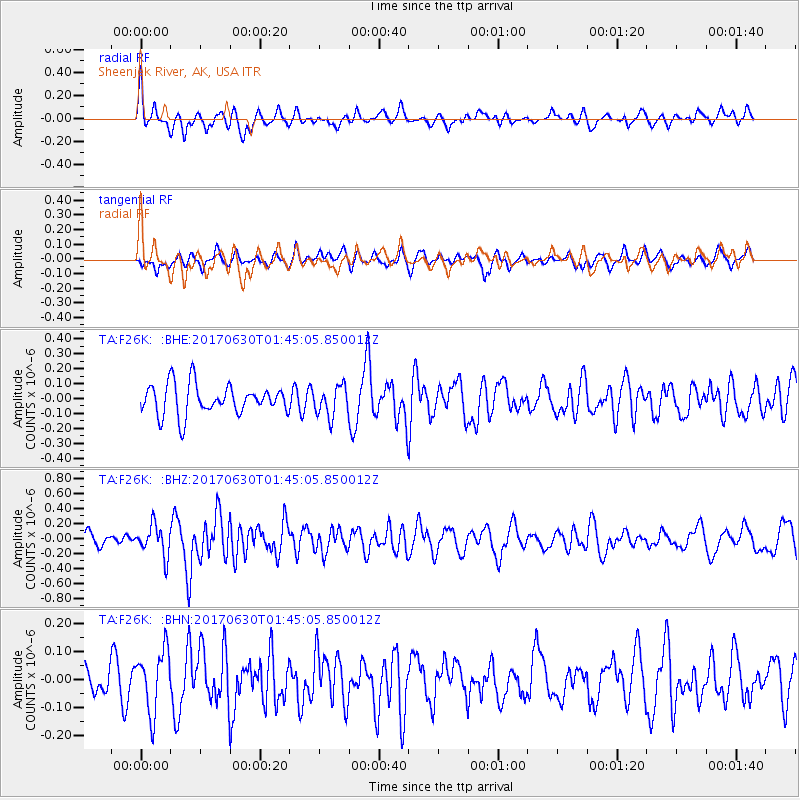
F26K Sheenjek River, AK, USA - Earthquake Result Viewer
*The percent match for this event was below the threshold and hence no stack was calculated.
| Earthquake location: |
Northern Mid-Atlantic Ridge |
| Earthquake latitude/longitude: |
33.7/-38.5 |
| Earthquake time(UTC): |
2017/06/30 (181) 01:34:58 GMT |
| Earthquake Depth: |
10 km |
| Earthquake Magnitude: |
5.8 Mwb |
| Earthquake Catalog/Contributor: |
NEIC PDE/us |
|
| Network: |
TA USArray Transportable Network (new EarthScope stations) |
| Station: |
F26K Sheenjek River, AK, USA |
| Lat/Lon: |
67.69 N/144.15 W |
| Elevation: |
683 m |
|
| Distance: |
64.8 deg |
| Az: |
336.027 deg |
| Baz: |
62.478 deg |
| Ray Param: |
$rayparam |
*The percent match for this event was below the threshold and hence was not used in the summary stack. |
|
| Radial Match: |
63.239677 % |
| Radial Bump: |
389 |
| Transverse Match: |
51.6923 % |
| Transverse Bump: |
400 |
| SOD ConfigId: |
13570011 |
| Insert Time: |
2019-04-28 07:35:55.829 +0000 |
| GWidth: |
2.5 |
| Max Bumps: |
400 |
| Tol: |
0.001 |
|
Signal To Noise
| Channel | StoN | STA | LTA |
| TA:F26K: :BHZ:20170630T01:45:05.850012Z | 2.379565 | 2.0554224E-7 | 8.6378066E-8 |
| TA:F26K: :BHN:20170630T01:45:05.850012Z | 2.0727246 | 1.1012455E-7 | 5.313034E-8 |
| TA:F26K: :BHE:20170630T01:45:05.850012Z | 0.9959894 | 1.0064851E-7 | 1.010538E-7 |
| Arrivals |
| Ps | |
| PpPs | |
| PsPs/PpSs | |


