You are here: Home > Network List > TA - USArray Transportable Network (new EarthScope stations) Stations List
> Station J20K Nowitna River, AK, USA > Earthquake Result Viewer
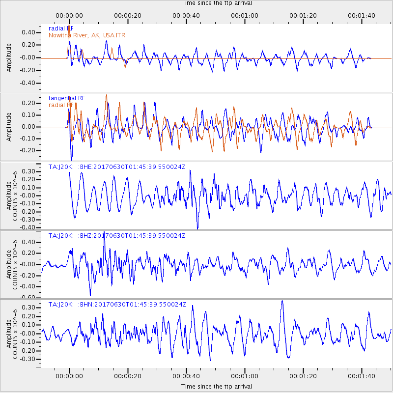
J20K Nowitna River, AK, USA - Earthquake Result Viewer
*The percent match for this event was below the threshold and hence no stack was calculated.
| Earthquake location: |
Northern Mid-Atlantic Ridge |
| Earthquake latitude/longitude: |
33.7/-38.5 |
| Earthquake time(UTC): |
2017/06/30 (181) 01:34:58 GMT |
| Earthquake Depth: |
10 km |
| Earthquake Magnitude: |
5.8 Mwb |
| Earthquake Catalog/Contributor: |
NEIC PDE/us |
|
| Network: |
TA USArray Transportable Network (new EarthScope stations) |
| Station: |
J20K Nowitna River, AK, USA |
| Lat/Lon: |
64.18 N/154.15 W |
| Elevation: |
314 m |
|
| Distance: |
70.2 deg |
| Az: |
335.171 deg |
| Baz: |
53.02 deg |
| Ray Param: |
$rayparam |
*The percent match for this event was below the threshold and hence was not used in the summary stack. |
|
| Radial Match: |
53.19953 % |
| Radial Bump: |
360 |
| Transverse Match: |
53.690674 % |
| Transverse Bump: |
376 |
| SOD ConfigId: |
13570011 |
| Insert Time: |
2019-04-28 07:36:13.824 +0000 |
| GWidth: |
2.5 |
| Max Bumps: |
400 |
| Tol: |
0.001 |
|
Signal To Noise
| Channel | StoN | STA | LTA |
| TA:J20K: :BHZ:20170630T01:45:39.550024Z | 2.2058847 | 1.6859168E-7 | 7.6428144E-8 |
| TA:J20K: :BHN:20170630T01:45:39.550024Z | 0.8543746 | 7.244192E-8 | 8.478942E-8 |
| TA:J20K: :BHE:20170630T01:45:39.550024Z | 0.5318593 | 8.051394E-8 | 1.5138205E-7 |
| Arrivals |
| Ps | |
| PpPs | |
| PsPs/PpSs | |


