You are here: Home > Network List > TA - USArray Transportable Network (new EarthScope stations) Stations List
> Station M31M Drury Creek, Yukon, CA > Earthquake Result Viewer
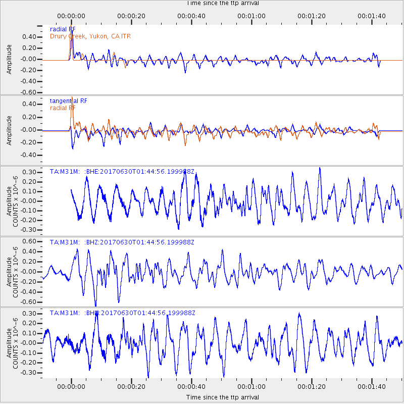
M31M Drury Creek, Yukon, CA - Earthquake Result Viewer
*The percent match for this event was below the threshold and hence no stack was calculated.
| Earthquake location: |
Northern Mid-Atlantic Ridge |
| Earthquake latitude/longitude: |
33.7/-38.5 |
| Earthquake time(UTC): |
2017/06/30 (181) 01:34:58 GMT |
| Earthquake Depth: |
10 km |
| Earthquake Magnitude: |
5.8 Mwb |
| Earthquake Catalog/Contributor: |
NEIC PDE/us |
|
| Network: |
TA USArray Transportable Network (new EarthScope stations) |
| Station: |
M31M Drury Creek, Yukon, CA |
| Lat/Lon: |
62.20 N/134.39 W |
| Elevation: |
639 m |
|
| Distance: |
63.3 deg |
| Az: |
328.544 deg |
| Baz: |
68.043 deg |
| Ray Param: |
$rayparam |
*The percent match for this event was below the threshold and hence was not used in the summary stack. |
|
| Radial Match: |
58.553978 % |
| Radial Bump: |
400 |
| Transverse Match: |
46.493004 % |
| Transverse Bump: |
365 |
| SOD ConfigId: |
13570011 |
| Insert Time: |
2019-04-28 07:36:25.368 +0000 |
| GWidth: |
2.5 |
| Max Bumps: |
400 |
| Tol: |
0.001 |
|
Signal To Noise
| Channel | StoN | STA | LTA |
| TA:M31M: :BHZ:20170630T01:44:56.199988Z | 3.4310422 | 2.5073493E-7 | 7.307836E-8 |
| TA:M31M: :BHN:20170630T01:44:56.199988Z | 0.5827042 | 5.435755E-8 | 9.328499E-8 |
| TA:M31M: :BHE:20170630T01:44:56.199988Z | 0.76181555 | 8.5457096E-8 | 1.1217557E-7 |
| Arrivals |
| Ps | |
| PpPs | |
| PsPs/PpSs | |


