You are here: Home > Network List > TA - USArray Transportable Network (new EarthScope stations) Stations List
> Station W25A X Bar L Ranch, Newkirk, NM, USA > Earthquake Result Viewer
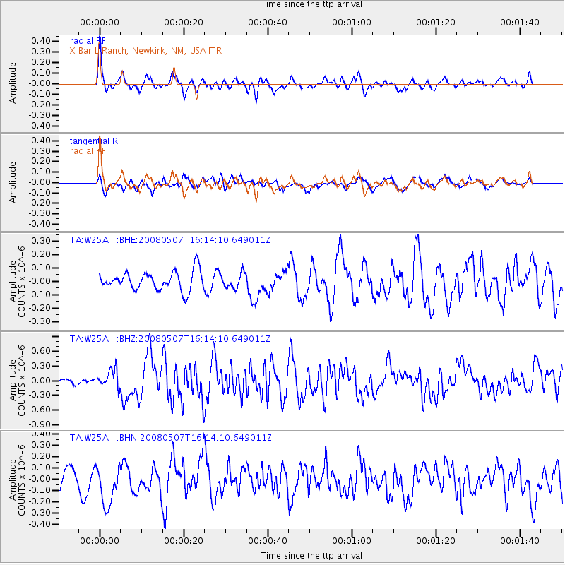
W25A X Bar L Ranch, Newkirk, NM, USA - Earthquake Result Viewer

| Earthquake location: |
Near East Coast Of Honshu, Japan |
| Earthquake latitude/longitude: |
36.2/141.5 |
| Earthquake time(UTC): |
2008/05/07 (128) 16:02:02 GMT |
| Earthquake Depth: |
19 km |
| Earthquake Magnitude: |
5.7 MB, 6.2 MW, 6.2 MW |
| Earthquake Catalog/Contributor: |
WHDF/NEIC |
|
| Network: |
TA USArray Transportable Network (new EarthScope stations) |
| Station: |
W25A X Bar L Ranch, Newkirk, NM, USA |
| Lat/Lon: |
35.22 N/104.46 W |
| Elevation: |
1446 m |
|
| Distance: |
86.1 deg |
| Az: |
48.57 deg |
| Baz: |
312.194 deg |
| Ray Param: |
0.04427667 |
| Estimated Moho Depth: |
40.0 km |
| Estimated Crust Vp/Vs: |
1.88 |
| Assumed Crust Vp: |
6.419 km/s |
| Estimated Crust Vs: |
3.41 km/s |
| Estimated Crust Poisson's Ratio: |
0.30 |
|
| Radial Match: |
80.231804 % |
| Radial Bump: |
400 |
| Transverse Match: |
54.85213 % |
| Transverse Bump: |
400 |
| SOD ConfigId: |
2504 |
| Insert Time: |
2010-03-06 01:28:34.156 +0000 |
| GWidth: |
2.5 |
| Max Bumps: |
400 |
| Tol: |
0.001 |
|
Signal To Noise
| Channel | StoN | STA | LTA |
| TA:W25A: :BHZ:20080507T16:14:10.649011Z | 2.506693 | 1.8287021E-7 | 7.295278E-8 |
| TA:W25A: :BHN:20080507T16:14:10.649011Z | 2.480465 | 1.8344599E-7 | 7.395629E-8 |
| TA:W25A: :BHE:20080507T16:14:10.649011Z | 0.8090194 | 5.631376E-8 | 6.960743E-8 |
| Arrivals |
| Ps | 5.6 SECOND |
| PpPs | 18 SECOND |
| PsPs/PpSs | 23 SECOND |


