You are here: Home > Network List > 5H - Central Virginia and South Carolina seismic monitoring experiment Stations List
> Station ANNI Yanceyville, VA > Earthquake Result Viewer
ANNI Yanceyville, VA - Earthquake Result Viewer
| Earthquake location: |
Near Coast Of Ecuador |
| Earthquake latitude/longitude: |
-0.3/-80.5 |
| Earthquake time(UTC): |
2017/06/30 (181) 22:29:44 GMT |
| Earthquake Depth: |
7.4 km |
| Earthquake Magnitude: |
6.0 Mww |
| Earthquake Catalog/Contributor: |
NEIC PDE/us |
|
| Network: |
5H Central Virginia and South Carolina seismic monitoring experiment |
| Station: |
ANNI Yanceyville, VA |
| Lat/Lon: |
37.94 N/77.97 W |
| Elevation: |
93 m |
|
| Distance: |
38.2 deg |
| Az: |
3.253 deg |
| Baz: |
184.116 deg |
| Ray Param: |
0.07573407 |
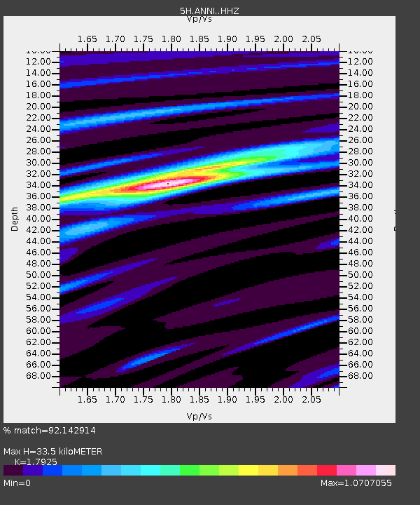
| Estimated Moho Depth: |
33.5 km |
| Estimated Crust Vp/Vs: |
1.79 |
| Assumed Crust Vp: |
6.565 km/s |
| Estimated Crust Vs: |
3.662 km/s |
| Estimated Crust Poisson's Ratio: |
0.27 |
|
| Radial Match: |
92.142914 % |
| Radial Bump: |
373 |
| Transverse Match: |
77.56723 % |
| Transverse Bump: |
400 |
| SOD ConfigId: |
13570011 |
| Insert Time: |
2019-04-28 07:38:33.461 +0000 |
| GWidth: |
2.5 |
| Max Bumps: |
400 |
| Tol: |
0.001 |
|

Signal To Noise
| Channel | StoN | STA | LTA |
| 5H:ANNI: :HHZ:20170630T22:36:32.784985Z | 19.426455 | 9.56828E-7 | 4.9253867E-8 |
| 5H:ANNI: :HHN:20170630T22:36:32.784985Z | 8.610367 | 5.375183E-7 | 6.242688E-8 |
| 5H:ANNI: :HHE:20170630T22:36:32.784985Z | 3.451751 | 2.3761628E-7 | 6.883934E-8 |
| Arrivals |
| Ps | 4.4 SECOND |
| PpPs | 13 SECOND |
| PsPs/PpSs | 18 SECOND |


