You are here: Home > Network List > 5H - Central Virginia and South Carolina seismic monitoring experiment Stations List
> Station BEAV Louisa, VA > Earthquake Result Viewer
BEAV Louisa, VA - Earthquake Result Viewer
| Earthquake location: |
Near Coast Of Ecuador |
| Earthquake latitude/longitude: |
-0.3/-80.5 |
| Earthquake time(UTC): |
2017/06/30 (181) 22:29:44 GMT |
| Earthquake Depth: |
7.4 km |
| Earthquake Magnitude: |
6.0 Mww |
| Earthquake Catalog/Contributor: |
NEIC PDE/us |
|
| Network: |
5H Central Virginia and South Carolina seismic monitoring experiment |
| Station: |
BEAV Louisa, VA |
| Lat/Lon: |
38.00 N/78.00 W |
| Elevation: |
118 m |
|
| Distance: |
38.2 deg |
| Az: |
3.203 deg |
| Baz: |
184.055 deg |
| Ray Param: |
0.0756987 |
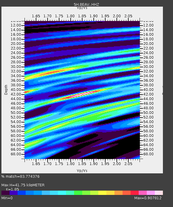
| Estimated Moho Depth: |
41.75 km |
| Estimated Crust Vp/Vs: |
1.85 |
| Assumed Crust Vp: |
6.565 km/s |
| Estimated Crust Vs: |
3.548 km/s |
| Estimated Crust Poisson's Ratio: |
0.29 |
|
| Radial Match: |
83.774376 % |
| Radial Bump: |
400 |
| Transverse Match: |
57.07725 % |
| Transverse Bump: |
400 |
| SOD ConfigId: |
13570011 |
| Insert Time: |
2019-04-28 07:38:45.164 +0000 |
| GWidth: |
2.5 |
| Max Bumps: |
400 |
| Tol: |
0.001 |
|

Signal To Noise
| Channel | StoN | STA | LTA |
| 5H:BEAV: :HHZ:20170630T22:36:33.300Z | 17.46907 | 8.8512394E-7 | 5.066806E-8 |
| 5H:BEAV: :HHN:20170630T22:36:33.300Z | 6.019747 | 6.6951367E-7 | 1.1121957E-7 |
| 5H:BEAV: :HHE:20170630T22:36:33.300Z | 1.5551684 | 1.658103E-7 | 1.0661888E-7 |
| Arrivals |
| Ps | 5.8 SECOND |
| PpPs | 17 SECOND |
| PsPs/PpSs | 23 SECOND |


