You are here: Home > Network List > 5H - Central Virginia and South Carolina seismic monitoring experiment Stations List
> Station BEAR Cumberland S.F., VA > Earthquake Result Viewer
BEAR Cumberland S.F., VA - Earthquake Result Viewer
| Earthquake location: |
Near Coast Of Ecuador |
| Earthquake latitude/longitude: |
-0.3/-80.5 |
| Earthquake time(UTC): |
2017/06/30 (181) 22:29:44 GMT |
| Earthquake Depth: |
7.4 km |
| Earthquake Magnitude: |
6.0 Mww |
| Earthquake Catalog/Contributor: |
NEIC PDE/us |
|
| Network: |
5H Central Virginia and South Carolina seismic monitoring experiment |
| Station: |
BEAR Cumberland S.F., VA |
| Lat/Lon: |
37.53 N/78.29 W |
| Elevation: |
107 m |
|
| Distance: |
37.7 deg |
| Az: |
2.884 deg |
| Baz: |
183.629 deg |
| Ray Param: |
0.07597884 |
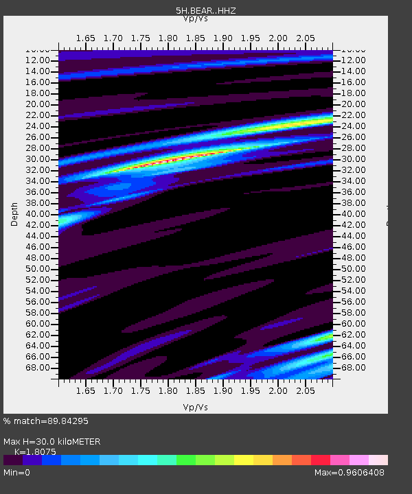
| Estimated Moho Depth: |
30.0 km |
| Estimated Crust Vp/Vs: |
1.81 |
| Assumed Crust Vp: |
6.419 km/s |
| Estimated Crust Vs: |
3.551 km/s |
| Estimated Crust Poisson's Ratio: |
0.28 |
|
| Radial Match: |
89.84295 % |
| Radial Bump: |
400 |
| Transverse Match: |
39.079906 % |
| Transverse Bump: |
400 |
| SOD ConfigId: |
13570011 |
| Insert Time: |
2019-04-28 07:38:45.184 +0000 |
| GWidth: |
2.5 |
| Max Bumps: |
400 |
| Tol: |
0.001 |
|

Signal To Noise
| Channel | StoN | STA | LTA |
| 5H:BEAR: :HHZ:20170630T22:36:29.224988Z | 12.679814 | 7.8230227E-7 | 6.169667E-8 |
| 5H:BEAR: :HHN:20170630T22:36:29.224988Z | 6.835584 | 4.175E-7 | 6.1077436E-8 |
| 5H:BEAR: :HHE:20170630T22:36:29.224988Z | 1.8650764 | 1.9668232E-7 | 1.0545537E-7 |
| Arrivals |
| Ps | 4.1 SECOND |
| PpPs | 12 SECOND |
| PsPs/PpSs | 16 SECOND |


