You are here: Home > Network List > 5H - Central Virginia and South Carolina seismic monitoring experiment Stations List
> Station DEBI Ferncliff, VA > Earthquake Result Viewer
DEBI Ferncliff, VA - Earthquake Result Viewer
| Earthquake location: |
Near Coast Of Ecuador |
| Earthquake latitude/longitude: |
-0.3/-80.5 |
| Earthquake time(UTC): |
2017/06/30 (181) 22:29:44 GMT |
| Earthquake Depth: |
7.4 km |
| Earthquake Magnitude: |
6.0 Mww |
| Earthquake Catalog/Contributor: |
NEIC PDE/us |
|
| Network: |
5H Central Virginia and South Carolina seismic monitoring experiment |
| Station: |
DEBI Ferncliff, VA |
| Lat/Lon: |
37.92 N/78.10 W |
| Elevation: |
137 m |
|
| Distance: |
38.1 deg |
| Az: |
3.084 deg |
| Baz: |
183.901 deg |
| Ray Param: |
0.07574559 |
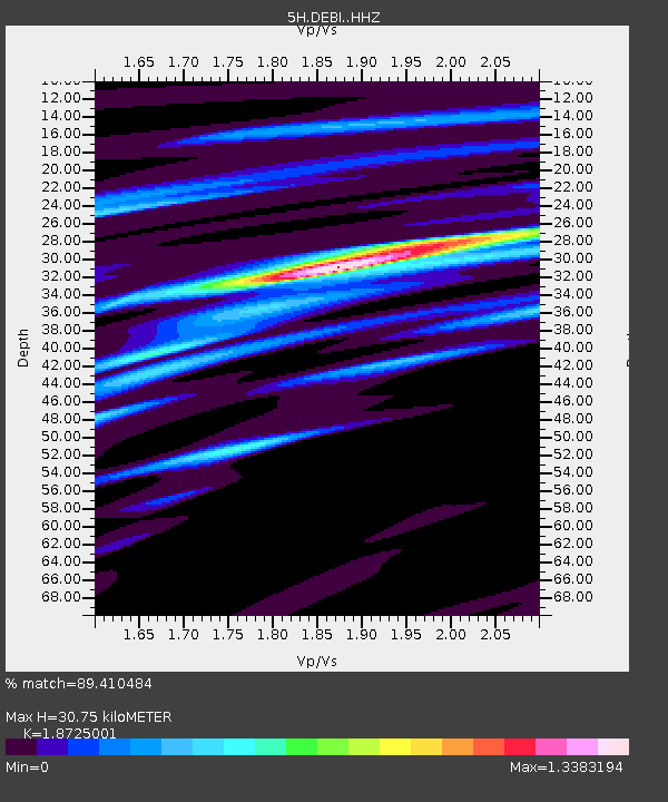
| Estimated Moho Depth: |
30.75 km |
| Estimated Crust Vp/Vs: |
1.87 |
| Assumed Crust Vp: |
6.419 km/s |
| Estimated Crust Vs: |
3.428 km/s |
| Estimated Crust Poisson's Ratio: |
0.30 |
|
| Radial Match: |
89.410484 % |
| Radial Bump: |
400 |
| Transverse Match: |
33.893887 % |
| Transverse Bump: |
400 |
| SOD ConfigId: |
13570011 |
| Insert Time: |
2019-04-28 07:38:47.549 +0000 |
| GWidth: |
2.5 |
| Max Bumps: |
400 |
| Tol: |
0.001 |
|

Signal To Noise
| Channel | StoN | STA | LTA |
| 5H:DEBI: :HHZ:20170630T22:36:32.609998Z | 17.453836 | 8.670497E-7 | 4.9676743E-8 |
| 5H:DEBI: :HHN:20170630T22:36:32.609998Z | 4.464938 | 5.835734E-7 | 1.3070134E-7 |
| 5H:DEBI: :HHE:20170630T22:36:32.609998Z | 0.66856843 | 2.5947563E-7 | 3.8810634E-7 |
| Arrivals |
| Ps | 4.5 SECOND |
| PpPs | 13 SECOND |
| PsPs/PpSs | 17 SECOND |


