You are here: Home > Network List > US - United States National Seismic Network Stations List
> Station MSO Missoula, Montana, USA > Earthquake Result Viewer
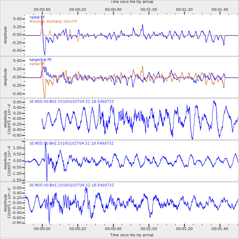
MSO Missoula, Montana, USA - Earthquake Result Viewer
*The percent match for this event was below the threshold and hence no stack was calculated.
| Earthquake location: |
Northeastern China |
| Earthquake latitude/longitude: |
44.9/130.0 |
| Earthquake time(UTC): |
2016/01/02 (002) 04:22:19 GMT |
| Earthquake Depth: |
583 km |
| Earthquake Magnitude: |
5.7 MWP |
| Earthquake Catalog/Contributor: |
NEIC PDE/NEIC COMCAT |
|
| Network: |
US United States National Seismic Network |
| Station: |
MSO Missoula, Montana, USA |
| Lat/Lon: |
46.83 N/113.94 W |
| Elevation: |
1264 m |
|
| Distance: |
72.8 deg |
| Az: |
40.215 deg |
| Baz: |
318.032 deg |
| Ray Param: |
$rayparam |
*The percent match for this event was below the threshold and hence was not used in the summary stack. |
|
| Radial Match: |
63.434433 % |
| Radial Bump: |
400 |
| Transverse Match: |
63.751354 % |
| Transverse Bump: |
400 |
| SOD ConfigId: |
1379111 |
| Insert Time: |
2016-01-16 05:36:30.246 +0000 |
| GWidth: |
2.5 |
| Max Bumps: |
400 |
| Tol: |
0.001 |
|
Signal To Noise
| Channel | StoN | STA | LTA |
| US:MSO:00:BHZ:20160102T04:32:18.649973Z | 3.9405398 | 5.5530325E-7 | 1.409206E-7 |
| US:MSO:00:BH1:20160102T04:32:18.649973Z | 1.3637292 | 2.3945177E-7 | 1.7558601E-7 |
| US:MSO:00:BH2:20160102T04:32:18.649973Z | 1.030737 | 2.2520375E-7 | 2.1848807E-7 |
| Arrivals |
| Ps | |
| PpPs | |
| PsPs/PpSs | |


