You are here: Home > Network List > TA - USArray Transportable Network (new EarthScope stations) Stations List
> Station W25A X Bar L Ranch, Newkirk, NM, USA > Earthquake Result Viewer
W25A X Bar L Ranch, Newkirk, NM, USA - Earthquake Result Viewer
| Earthquake location: |
Vanuatu Islands |
| Earthquake latitude/longitude: |
-13.0/166.5 |
| Earthquake time(UTC): |
2009/10/07 (280) 22:03:14 GMT |
| Earthquake Depth: |
45 km |
| Earthquake Magnitude: |
6.4 MB, 7.3 MS, 7.6 MW, 7.7 MW |
| Earthquake Catalog/Contributor: |
WHDF/NEIC |
|
| Network: |
TA USArray Transportable Network (new EarthScope stations) |
| Station: |
W25A X Bar L Ranch, Newkirk, NM, USA |
| Lat/Lon: |
35.22 N/104.46 W |
| Elevation: |
1446 m |
|
| Distance: |
96.6 deg |
| Az: |
55.5 deg |
| Baz: |
258.822 deg |
| Ray Param: |
0.04044106 |
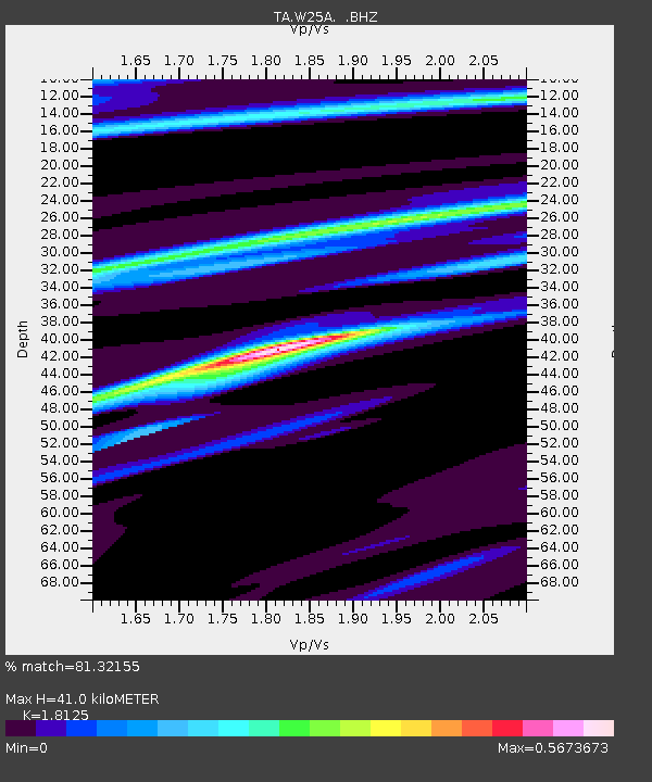
| Estimated Moho Depth: |
41.0 km |
| Estimated Crust Vp/Vs: |
1.81 |
| Assumed Crust Vp: |
6.419 km/s |
| Estimated Crust Vs: |
3.542 km/s |
| Estimated Crust Poisson's Ratio: |
0.28 |
|
| Radial Match: |
81.32155 % |
| Radial Bump: |
400 |
| Transverse Match: |
53.086777 % |
| Transverse Bump: |
400 |
| SOD ConfigId: |
2622 |
| Insert Time: |
2010-03-06 01:29:19.707 +0000 |
| GWidth: |
2.5 |
| Max Bumps: |
400 |
| Tol: |
0.001 |
|
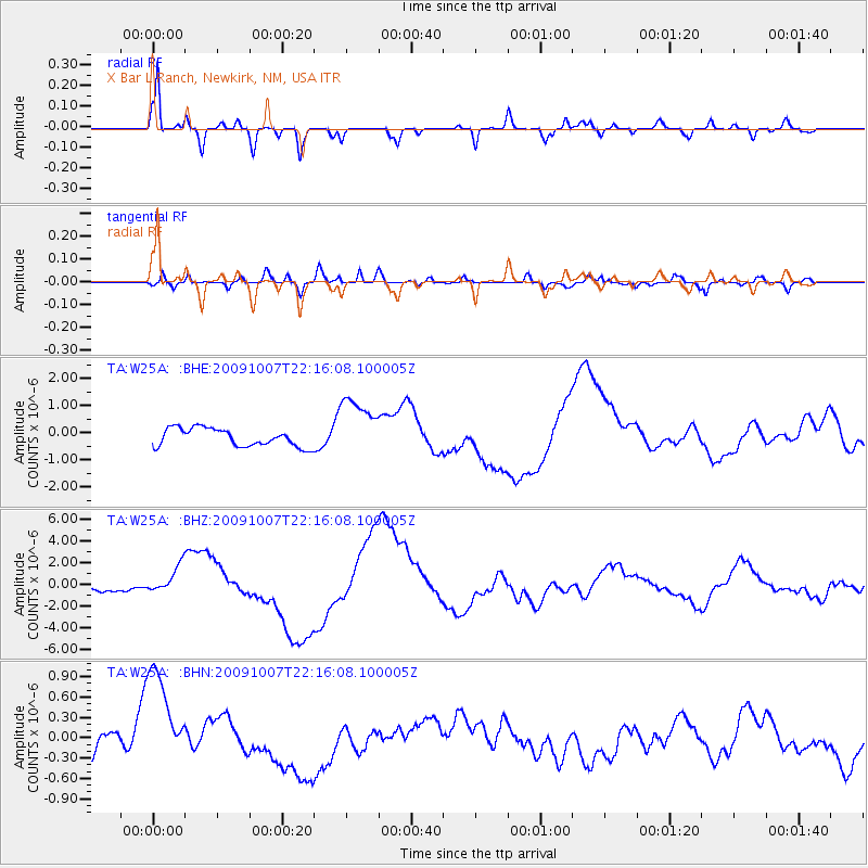
Signal To Noise
| Channel | StoN | STA | LTA |
| TA:W25A: :BHZ:20091007T22:16:08.100005Z | 4.4450917 | 1.3021628E-6 | 2.9294395E-7 |
| TA:W25A: :BHN:20091007T22:16:08.100005Z | 3.9028044 | 8.086961E-7 | 2.0720897E-7 |
| TA:W25A: :BHE:20091007T22:16:08.100005Z | 3.4546316 | 1.1349912E-6 | 3.285419E-7 |
| Arrivals |
| Ps | 5.3 SECOND |
| PpPs | 18 SECOND |
| PsPs/PpSs | 23 SECOND |


