You are here: Home > Network List > TA - USArray Transportable Network (new EarthScope stations) Stations List
> Station W25A X Bar L Ranch, Newkirk, NM, USA > Earthquake Result Viewer
W25A X Bar L Ranch, Newkirk, NM, USA - Earthquake Result Viewer
| Earthquake location: |
Near East Coast Of Honshu, Japan |
| Earthquake latitude/longitude: |
35.5/140.9 |
| Earthquake time(UTC): |
2009/06/06 (157) 05:52:43 GMT |
| Earthquake Depth: |
34 km |
| Earthquake Magnitude: |
5.8 MB, 5.4 MS, 5.8 MW, 5.7 MW |
| Earthquake Catalog/Contributor: |
WHDF/NEIC |
|
| Network: |
TA USArray Transportable Network (new EarthScope stations) |
| Station: |
W25A X Bar L Ranch, Newkirk, NM, USA |
| Lat/Lon: |
35.22 N/104.46 W |
| Elevation: |
1446 m |
|
| Distance: |
86.9 deg |
| Az: |
48.192 deg |
| Baz: |
312.016 deg |
| Ray Param: |
0.043637697 |
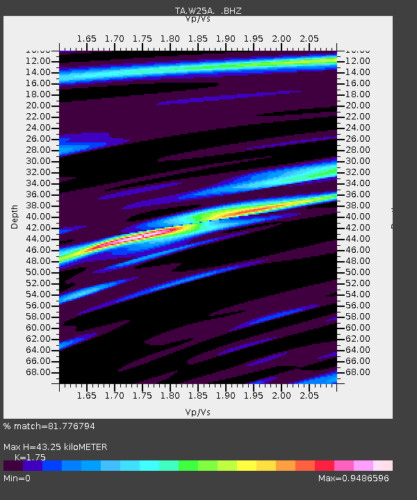
| Estimated Moho Depth: |
43.25 km |
| Estimated Crust Vp/Vs: |
1.75 |
| Assumed Crust Vp: |
6.419 km/s |
| Estimated Crust Vs: |
3.668 km/s |
| Estimated Crust Poisson's Ratio: |
0.26 |
|
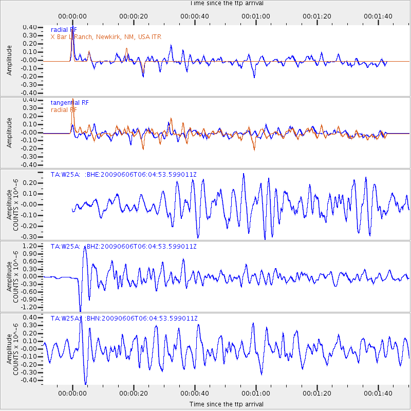
| Radial Match: |
81.776794 % |
| Radial Bump: |
400 |
| Transverse Match: |
80.80788 % |
| Transverse Bump: |
400 |
| SOD ConfigId: |
2648 |
| Insert Time: |
2010-03-06 01:29:29.647 +0000 |
| GWidth: |
2.5 |
| Max Bumps: |
400 |
| Tol: |
0.001 |
|
Signal To Noise
| Channel | StoN | STA | LTA |
| TA:W25A: :BHZ:20090606T06:04:53.599011Z | 14.157755 | 6.670598E-7 | 4.7116213E-8 |
| TA:W25A: :BHN:20090606T06:04:53.599011Z | 3.6567783 | 2.2999541E-7 | 6.289564E-8 |
| TA:W25A: :BHE:20090606T06:04:53.599011Z | 2.701368 | 1.2754151E-7 | 4.7213675E-8 |
| Arrivals |
| Ps | 5.2 SECOND |
| PpPs | 18 SECOND |
| PsPs/PpSs | 23 SECOND |


