You are here: Home > Network List > TA - USArray Transportable Network (new EarthScope stations) Stations List
> Station W25A X Bar L Ranch, Newkirk, NM, USA > Earthquake Result Viewer
W25A X Bar L Ranch, Newkirk, NM, USA - Earthquake Result Viewer

| Earthquake location: |
South Of Panama |
| Earthquake latitude/longitude: |
5.7/-82.8 |
| Earthquake time(UTC): |
2009/03/12 (071) 23:23:34 GMT |
| Earthquake Depth: |
9.0 km |
| Earthquake Magnitude: |
6.1 MB, 5.9 MS, 6.3 MW, 6.2 MW |
| Earthquake Catalog/Contributor: |
WHDF/NEIC |
|
| Network: |
TA USArray Transportable Network (new EarthScope stations) |
| Station: |
W25A X Bar L Ranch, Newkirk, NM, USA |
| Lat/Lon: |
35.22 N/104.46 W |
| Elevation: |
1446 m |
|
| Distance: |
35.6 deg |
| Az: |
328.631 deg |
| Baz: |
140.752 deg |
| Ray Param: |
0.07716531 |
| Estimated Moho Depth: |
30.0 km |
| Estimated Crust Vp/Vs: |
2.04 |
| Assumed Crust Vp: |
6.419 km/s |
| Estimated Crust Vs: |
3.143 km/s |
| Estimated Crust Poisson's Ratio: |
0.34 |
|
| Radial Match: |
94.0428 % |
| Radial Bump: |
349 |
| Transverse Match: |
71.53637 % |
| Transverse Bump: |
333 |
| SOD ConfigId: |
2658 |
| Insert Time: |
2010-03-06 01:29:34.981 +0000 |
| GWidth: |
2.5 |
| Max Bumps: |
400 |
| Tol: |
0.001 |
|
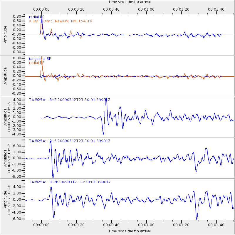
Signal To Noise
| Channel | StoN | STA | LTA |
| TA:W25A: :BHZ:20090312T23:30:01.39901Z | 7.8595996 | 1.4097233E-6 | 1.7936325E-7 |
| TA:W25A: :BHN:20090312T23:30:01.39901Z | 3.8729568 | 4.9599333E-7 | 1.280658E-7 |
| TA:W25A: :BHE:20090312T23:30:01.39901Z | 3.4703643 | 4.621172E-7 | 1.3316101E-7 |
| Arrivals |
| Ps | 5.2 SECOND |
| PpPs | 13 SECOND |
| PsPs/PpSs | 19 SECOND |


