You are here: Home > Network List > TA - USArray Transportable Network (new EarthScope stations) Stations List
> Station W25A X Bar L Ranch, Newkirk, NM, USA > Earthquake Result Viewer
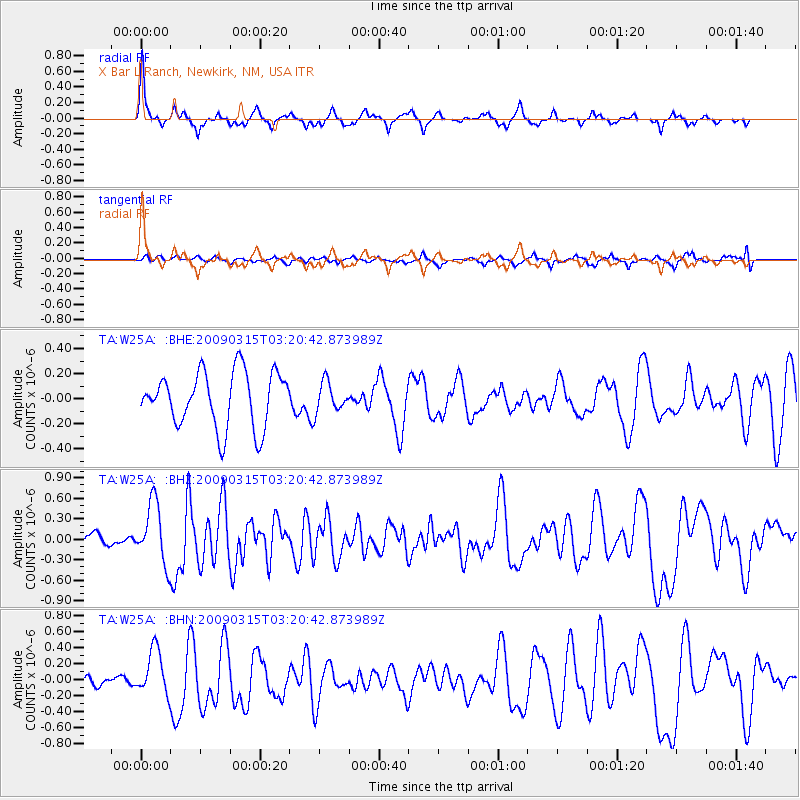
W25A X Bar L Ranch, Newkirk, NM, USA - Earthquake Result Viewer
| Earthquake location: |
Galapagos Islands Region |
| Earthquake latitude/longitude: |
2.4/-95.1 |
| Earthquake time(UTC): |
2009/03/15 (074) 03:14:31 GMT |
| Earthquake Depth: |
10 km |
| Earthquake Magnitude: |
5.5 MS, 5.4 MB, 5.8 MW, 5.8 MW |
| Earthquake Catalog/Contributor: |
WHDF/NEIC |
|
| Network: |
TA USArray Transportable Network (new EarthScope stations) |
| Station: |
W25A X Bar L Ranch, Newkirk, NM, USA |
| Lat/Lon: |
35.22 N/104.46 W |
| Elevation: |
1446 m |
|
| Distance: |
33.8 deg |
| Az: |
346.17 deg |
| Baz: |
163.041 deg |
| Ray Param: |
0.07806014 |
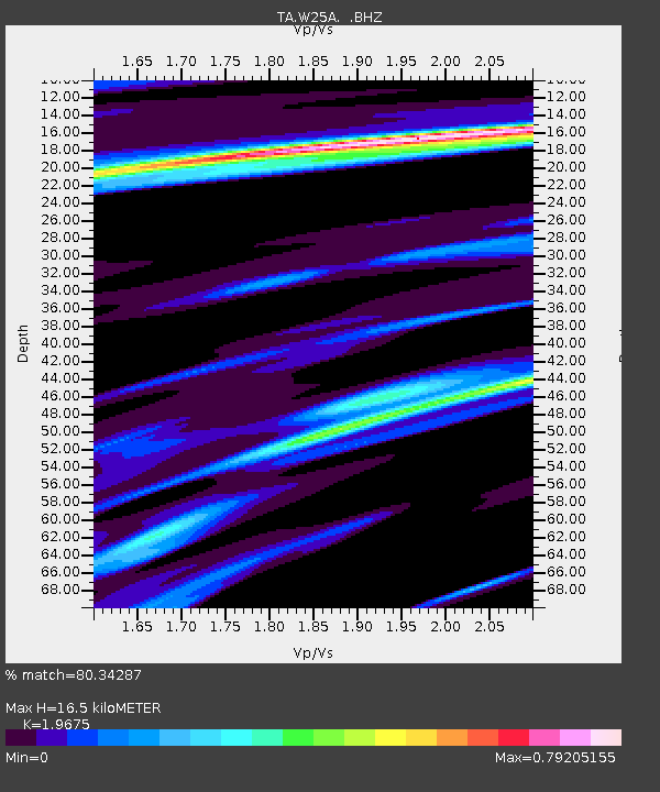
| Estimated Moho Depth: |
16.5 km |
| Estimated Crust Vp/Vs: |
1.97 |
| Assumed Crust Vp: |
6.419 km/s |
| Estimated Crust Vs: |
3.263 km/s |
| Estimated Crust Poisson's Ratio: |
0.33 |
|
| Radial Match: |
80.34287 % |
| Radial Bump: |
355 |
| Transverse Match: |
53.712368 % |
| Transverse Bump: |
400 |
| SOD ConfigId: |
2658 |
| Insert Time: |
2010-03-06 01:29:36.237 +0000 |
| GWidth: |
2.5 |
| Max Bumps: |
400 |
| Tol: |
0.001 |
|
Signal To Noise
| Channel | StoN | STA | LTA |
| TA:W25A: :BHZ:20090315T03:20:42.873989Z | 3.1206832 | 4.4626805E-7 | 1.4300332E-7 |
| TA:W25A: :BHN:20090315T03:20:42.873989Z | 2.3989723 | 2.8345224E-7 | 1.1815569E-7 |
| TA:W25A: :BHE:20090315T03:20:42.873989Z | 0.5311659 | 1.1645731E-7 | 2.1924846E-7 |
| Arrivals |
| Ps | 2.7 SECOND |
| PpPs | 7.1 SECOND |
| PsPs/PpSs | 9.8 SECOND |


