You are here: Home > Network List > CN - Canadian National Seismograph Network Stations List
> Station LLLB Lillooet, BC, CA > Earthquake Result Viewer
LLLB Lillooet, BC, CA - Earthquake Result Viewer
| Earthquake location: |
Near Coast Of Ecuador |
| Earthquake latitude/longitude: |
-0.3/-80.5 |
| Earthquake time(UTC): |
2017/06/30 (181) 22:29:44 GMT |
| Earthquake Depth: |
7.4 km |
| Earthquake Magnitude: |
6.0 Mww |
| Earthquake Catalog/Contributor: |
NEIC PDE/us |
|
| Network: |
CN Canadian National Seismograph Network |
| Station: |
LLLB Lillooet, BC, CA |
| Lat/Lon: |
50.61 N/121.88 W |
| Elevation: |
700 m |
|
| Distance: |
61.7 deg |
| Az: |
331.432 deg |
| Baz: |
131.366 deg |
| Ray Param: |
0.060695246 |
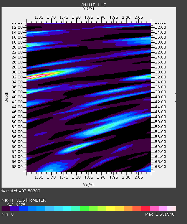
| Estimated Moho Depth: |
31.5 km |
| Estimated Crust Vp/Vs: |
1.64 |
| Assumed Crust Vp: |
6.597 km/s |
| Estimated Crust Vs: |
4.029 km/s |
| Estimated Crust Poisson's Ratio: |
0.20 |
|
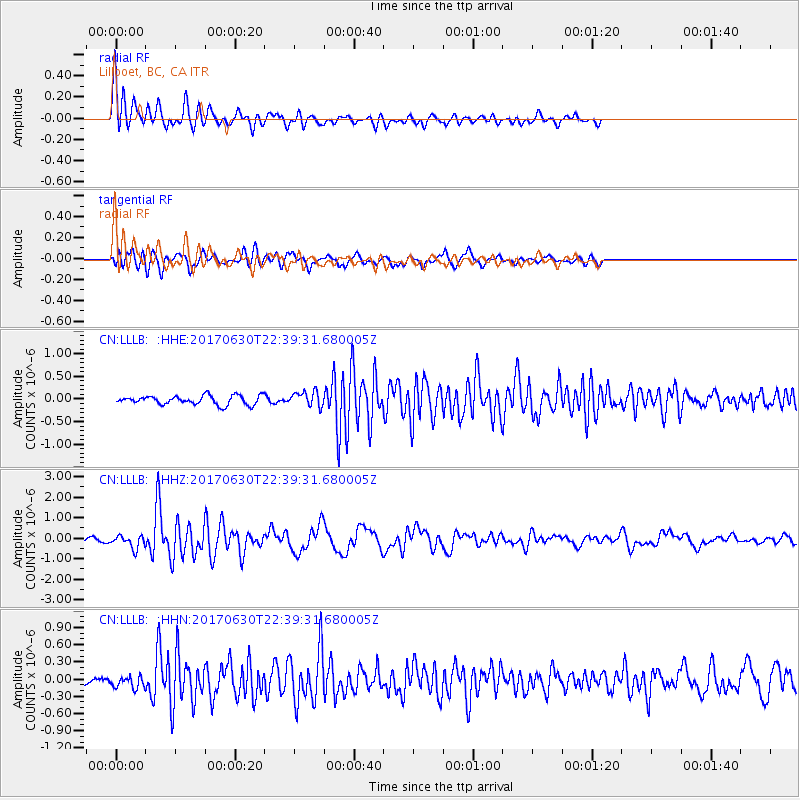
| Radial Match: |
87.58709 % |
| Radial Bump: |
400 |
| Transverse Match: |
76.10308 % |
| Transverse Bump: |
400 |
| SOD ConfigId: |
13570011 |
| Insert Time: |
2019-04-28 07:42:10.722 +0000 |
| GWidth: |
2.5 |
| Max Bumps: |
400 |
| Tol: |
0.001 |
|
Signal To Noise
| Channel | StoN | STA | LTA |
| CN:LLLB: :HHZ:20170630T22:39:31.680005Z | 3.2886453 | 3.151227E-7 | 9.582143E-8 |
| CN:LLLB: :HHN:20170630T22:39:31.680005Z | 1.7899911 | 1.0574037E-7 | 5.9073123E-8 |
| CN:LLLB: :HHE:20170630T22:39:31.680005Z | 1.6881987 | 1.685671E-7 | 9.985027E-8 |
| Arrivals |
| Ps | 3.2 SECOND |
| PpPs | 12 SECOND |
| PsPs/PpSs | 15 SECOND |


