You are here: Home > Network List > LD - Lamont-Doherty Cooperative Seismographic Network Stations List
> Station BMNY Brushton-Moira, New York > Earthquake Result Viewer
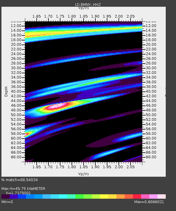
BMNY Brushton-Moira, New York - Earthquake Result Viewer
| Earthquake location: |
Near Coast Of Ecuador |
| Earthquake latitude/longitude: |
-0.3/-80.5 |
| Earthquake time(UTC): |
2017/06/30 (181) 22:29:44 GMT |
| Earthquake Depth: |
7.4 km |
| Earthquake Magnitude: |
6.0 Mww |
| Earthquake Catalog/Contributor: |
NEIC PDE/us |
|
| Network: |
LD Lamont-Doherty Cooperative Seismographic Network |
| Station: |
BMNY Brushton-Moira, New York |
| Lat/Lon: |
44.84 N/74.51 W |
| Elevation: |
115 m |
|
| Distance: |
45.3 deg |
| Az: |
6.006 deg |
| Baz: |
188.457 deg |
| Ray Param: |
0.0713808 |
| Estimated Moho Depth: |
45.75 km |
| Estimated Crust Vp/Vs: |
1.74 |
| Assumed Crust Vp: |
6.419 km/s |
| Estimated Crust Vs: |
3.695 km/s |
| Estimated Crust Poisson's Ratio: |
0.25 |
|
| Radial Match: |
88.54034 % |
| Radial Bump: |
400 |
| Transverse Match: |
67.95205 % |
| Transverse Bump: |
400 |
| SOD ConfigId: |
13570011 |
| Insert Time: |
2019-04-28 07:43:44.969 +0000 |
| GWidth: |
2.5 |
| Max Bumps: |
400 |
| Tol: |
0.001 |
|

Signal To Noise
| Channel | StoN | STA | LTA |
| LD:BMNY: :HHZ:20170630T22:37:31.159985Z | 9.403853 | 6.8052884E-7 | 7.2367015E-8 |
| LD:BMNY: :HHN:20170630T22:37:31.159985Z | 6.300244 | 3.4959564E-7 | 5.548922E-8 |
| LD:BMNY: :HHE:20170630T22:37:31.159985Z | 1.1206622 | 7.624611E-8 | 6.803666E-8 |
| Arrivals |
| Ps | 5.6 SECOND |
| PpPs | 18 SECOND |
| PsPs/PpSs | 24 SECOND |


