You are here: Home > Network List > CI - Caltech Regional Seismic Network Stations List
> Station ARV Arvin, Arvin, CA, USA > Earthquake Result Viewer
ARV Arvin, Arvin, CA, USA - Earthquake Result Viewer
| Earthquake location: |
Peru-Ecuador Border Region |
| Earthquake latitude/longitude: |
-2.3/-77.8 |
| Earthquake time(UTC): |
2007/11/16 (320) 03:13:00 GMT |
| Earthquake Depth: |
123 km |
| Earthquake Magnitude: |
6.3 MB, 6.8 MW, 6.7 MW |
| Earthquake Catalog/Contributor: |
WHDF/NEIC |
|
| Network: |
CI Caltech Regional Seismic Network |
| Station: |
ARV Arvin, Arvin, CA, USA |
| Lat/Lon: |
35.13 N/118.83 W |
| Elevation: |
258 m |
|
| Distance: |
53.5 deg |
| Az: |
317.999 deg |
| Baz: |
125.346 deg |
| Ray Param: |
0.06567289 |
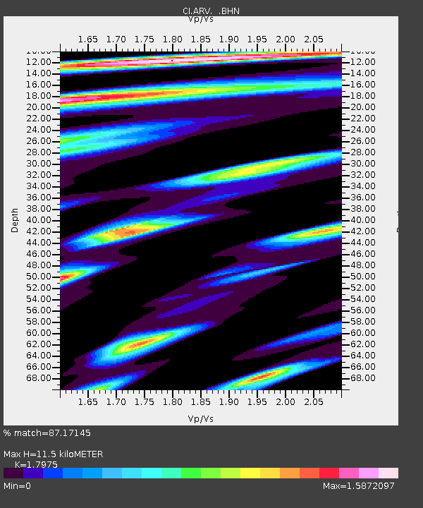
| Estimated Moho Depth: |
11.5 km |
| Estimated Crust Vp/Vs: |
1.80 |
| Assumed Crust Vp: |
6.1 km/s |
| Estimated Crust Vs: |
3.394 km/s |
| Estimated Crust Poisson's Ratio: |
0.28 |
|
| Radial Match: |
87.17145 % |
| Radial Bump: |
400 |
| Transverse Match: |
84.75555 % |
| Transverse Bump: |
400 |
| SOD ConfigId: |
2564 |
| Insert Time: |
2010-02-26 01:18:38.888 +0000 |
| GWidth: |
2.5 |
| Max Bumps: |
400 |
| Tol: |
0.001 |
|

Signal To Noise
| Channel | StoN | STA | LTA |
| CI:ARV: :BHN:20071116T03:21:37.044011Z | 3.427685 | 1.2805898E-6 | 3.7360195E-7 |
| CI:ARV: :BHE:20071116T03:21:37.044011Z | 1.8486127 | 8.9159045E-7 | 4.823025E-7 |
| CI:ARV: :BHZ:20071116T03:21:37.044011Z | 8.795703 | 2.243176E-6 | 2.550309E-7 |
| Arrivals |
| Ps | 1.6 SECOND |
| PpPs | 5.0 SECOND |
| PsPs/PpSs | 6.6 SECOND |


