You are here: Home > Network List > UW - Pacific Northwest Regional Seismic Network Stations List
> Station MRBL Marblemount, WA, USA > Earthquake Result Viewer
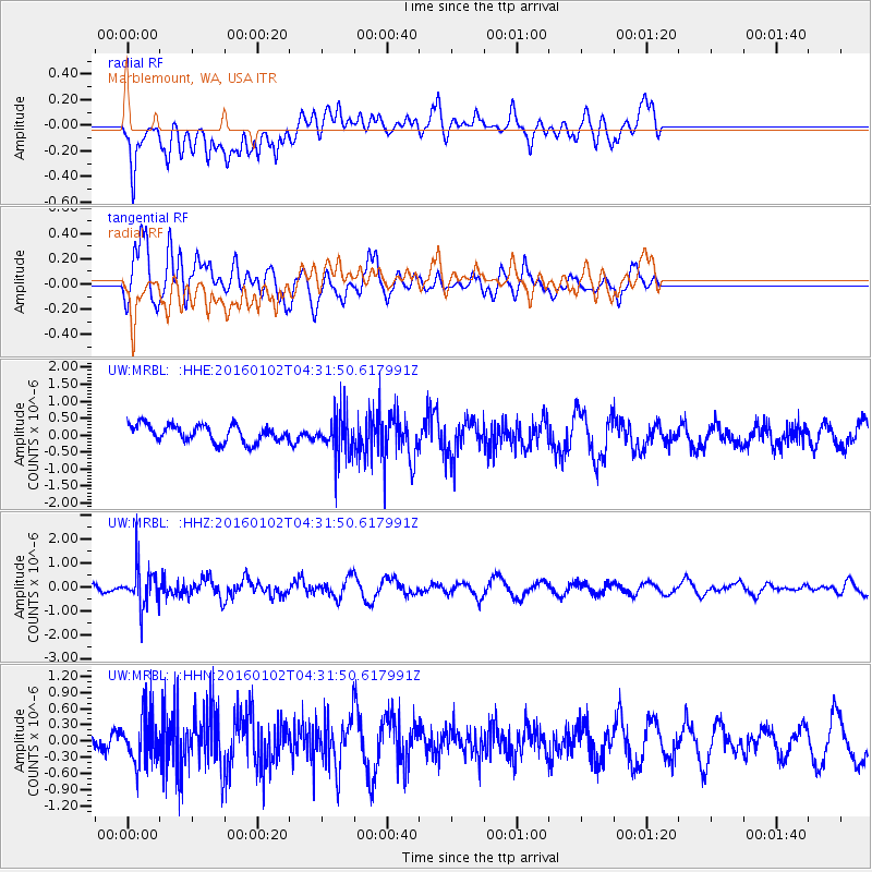
MRBL Marblemount, WA, USA - Earthquake Result Viewer
*The percent match for this event was below the threshold and hence no stack was calculated.
| Earthquake location: |
Northeastern China |
| Earthquake latitude/longitude: |
44.9/130.0 |
| Earthquake time(UTC): |
2016/01/02 (002) 04:22:19 GMT |
| Earthquake Depth: |
583 km |
| Earthquake Magnitude: |
5.7 MWP |
| Earthquake Catalog/Contributor: |
NEIC PDE/NEIC COMCAT |
|
| Network: |
UW Pacific Northwest Regional Seismic Network |
| Station: |
MRBL Marblemount, WA, USA |
| Lat/Lon: |
48.52 N/121.48 W |
| Elevation: |
75 m |
|
| Distance: |
68.0 deg |
| Az: |
42.835 deg |
| Baz: |
313.348 deg |
| Ray Param: |
$rayparam |
*The percent match for this event was below the threshold and hence was not used in the summary stack. |
|
| Radial Match: |
70.41588 % |
| Radial Bump: |
400 |
| Transverse Match: |
68.53028 % |
| Transverse Bump: |
400 |
| SOD ConfigId: |
1379111 |
| Insert Time: |
2016-01-16 05:40:00.107 +0000 |
| GWidth: |
2.5 |
| Max Bumps: |
400 |
| Tol: |
0.001 |
|
Signal To Noise
| Channel | StoN | STA | LTA |
| UW:MRBL: :HHZ:20160102T04:31:50.617991Z | 4.9072266 | 8.1827073E-7 | 1.6674811E-7 |
| UW:MRBL: :HHN:20160102T04:31:50.617991Z | 2.1736388 | 4.6622472E-7 | 2.1449043E-7 |
| UW:MRBL: :HHE:20160102T04:31:50.617991Z | 2.467441 | 6.186092E-7 | 2.507088E-7 |
| Arrivals |
| Ps | |
| PpPs | |
| PsPs/PpSs | |


