You are here: Home > Network List > TA - USArray Transportable Network (new EarthScope stations) Stations List
> Station L44A Lake County Forest Preserve, Grayslake, IL, USA > Earthquake Result Viewer
L44A Lake County Forest Preserve, Grayslake, IL, USA - Earthquake Result Viewer
| Earthquake location: |
Near Coast Of Ecuador |
| Earthquake latitude/longitude: |
-0.3/-80.5 |
| Earthquake time(UTC): |
2017/06/30 (181) 22:29:44 GMT |
| Earthquake Depth: |
7.4 km |
| Earthquake Magnitude: |
6.0 Mww |
| Earthquake Catalog/Contributor: |
NEIC PDE/us |
|
| Network: |
TA USArray Transportable Network (new EarthScope stations) |
| Station: |
L44A Lake County Forest Preserve, Grayslake, IL, USA |
| Lat/Lon: |
42.18 N/87.91 W |
| Elevation: |
202 m |
|
| Distance: |
42.8 deg |
| Az: |
351.901 deg |
| Baz: |
169.074 deg |
| Ray Param: |
0.07293806 |
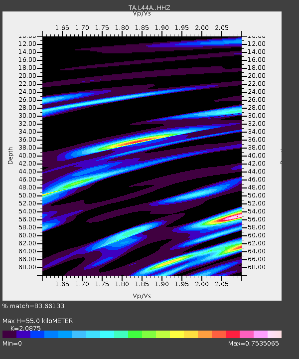
| Estimated Moho Depth: |
55.0 km |
| Estimated Crust Vp/Vs: |
2.09 |
| Assumed Crust Vp: |
6.483 km/s |
| Estimated Crust Vs: |
3.105 km/s |
| Estimated Crust Poisson's Ratio: |
0.35 |
|
| Radial Match: |
83.66133 % |
| Radial Bump: |
382 |
| Transverse Match: |
54.488136 % |
| Transverse Bump: |
400 |
| SOD ConfigId: |
13570011 |
| Insert Time: |
2019-04-28 07:49:06.873 +0000 |
| GWidth: |
2.5 |
| Max Bumps: |
400 |
| Tol: |
0.001 |
|

Signal To Noise
| Channel | StoN | STA | LTA |
| TA:L44A: :HHZ:20170630T22:37:11.56001Z | 5.3975196 | 5.9788374E-7 | 1.1077009E-7 |
| TA:L44A: :HHN:20170630T22:37:11.56001Z | 2.4806962 | 4.19584E-7 | 1.6913962E-7 |
| TA:L44A: :HHE:20170630T22:37:11.56001Z | 1.1902944 | 1.8267303E-7 | 1.5346879E-7 |
| Arrivals |
| Ps | 9.8 SECOND |
| PpPs | 25 SECOND |
| PsPs/PpSs | 35 SECOND |


