You are here: Home > Network List > TA - USArray Transportable Network (new EarthScope stations) Stations List
> Station A05A Maple Falls, WA, USA > Earthquake Result Viewer
A05A Maple Falls, WA, USA - Earthquake Result Viewer
| Earthquake location: |
South Of Panama |
| Earthquake latitude/longitude: |
4.6/-78.5 |
| Earthquake time(UTC): |
2007/03/18 (077) 02:11:05 GMT |
| Earthquake Depth: |
8.0 km |
| Earthquake Magnitude: |
6.4 MB, 5.7 MS, 6.2 MW, 6.1 MW |
| Earthquake Catalog/Contributor: |
WHDF/NEIC |
|
| Network: |
TA USArray Transportable Network (new EarthScope stations) |
| Station: |
A05A Maple Falls, WA, USA |
| Lat/Lon: |
49.00 N/122.09 W |
| Elevation: |
174 m |
|
| Distance: |
57.6 deg |
| Az: |
327.484 deg |
| Baz: |
125.549 deg |
| Ray Param: |
0.06336981 |
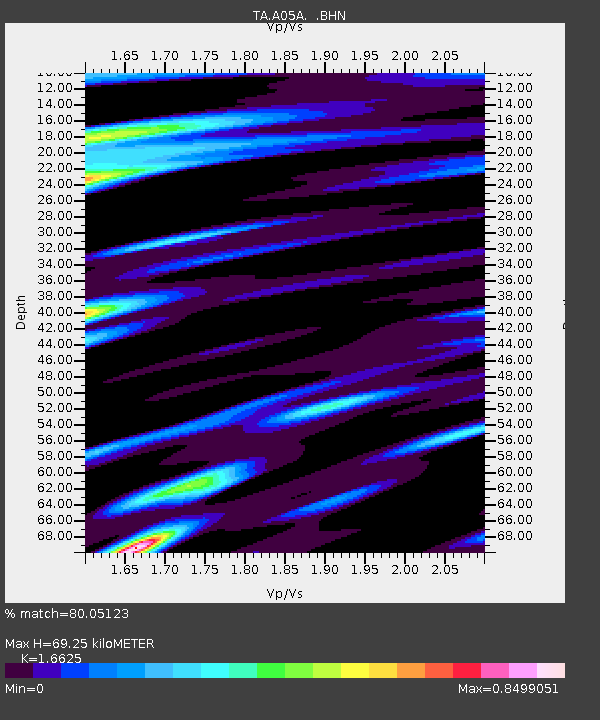
| Estimated Moho Depth: |
69.25 km |
| Estimated Crust Vp/Vs: |
1.66 |
| Assumed Crust Vp: |
6.566 km/s |
| Estimated Crust Vs: |
3.95 km/s |
| Estimated Crust Poisson's Ratio: |
0.22 |
|
| Radial Match: |
80.05123 % |
| Radial Bump: |
400 |
| Transverse Match: |
79.88169 % |
| Transverse Bump: |
400 |
| SOD ConfigId: |
2564 |
| Insert Time: |
2010-03-06 01:32:15.410 +0000 |
| GWidth: |
2.5 |
| Max Bumps: |
400 |
| Tol: |
0.001 |
|

Signal To Noise
| Channel | StoN | STA | LTA |
| TA:A05A: :BHN:20070318T02:20:24.950022Z | 7.5663366 | 1.0218922E-6 | 1.3505773E-7 |
| TA:A05A: :BHE:20070318T02:20:24.950022Z | 7.16581 | 1.0308626E-6 | 1.4385849E-7 |
| TA:A05A: :BHZ:20070318T02:20:24.950022Z | 19.356453 | 3.358866E-6 | 1.7352693E-7 |
| Arrivals |
| Ps | 7.4 SECOND |
| PpPs | 27 SECOND |
| PsPs/PpSs | 34 SECOND |


