You are here: Home > Network List > TA - USArray Transportable Network (new EarthScope stations) Stations List
> Station MSTX Muleshoe, TX, USA > Earthquake Result Viewer
MSTX Muleshoe, TX, USA - Earthquake Result Viewer
| Earthquake location: |
Near Coast Of Ecuador |
| Earthquake latitude/longitude: |
-0.3/-80.5 |
| Earthquake time(UTC): |
2017/06/30 (181) 22:29:44 GMT |
| Earthquake Depth: |
7.4 km |
| Earthquake Magnitude: |
6.0 Mww |
| Earthquake Catalog/Contributor: |
NEIC PDE/us |
|
| Network: |
TA USArray Transportable Network (new EarthScope stations) |
| Station: |
MSTX Muleshoe, TX, USA |
| Lat/Lon: |
33.97 N/102.77 W |
| Elevation: |
1167 m |
|
| Distance: |
40.0 deg |
| Az: |
330.677 deg |
| Baz: |
143.894 deg |
| Ray Param: |
0.074648075 |
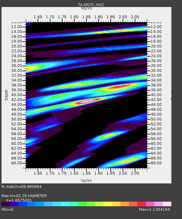
| Estimated Moho Depth: |
42.25 km |
| Estimated Crust Vp/Vs: |
1.86 |
| Assumed Crust Vp: |
6.129 km/s |
| Estimated Crust Vs: |
3.3 km/s |
| Estimated Crust Poisson's Ratio: |
0.30 |
|
| Radial Match: |
89.690994 % |
| Radial Bump: |
314 |
| Transverse Match: |
69.29186 % |
| Transverse Bump: |
400 |
| SOD ConfigId: |
13570011 |
| Insert Time: |
2019-04-28 07:49:21.647 +0000 |
| GWidth: |
2.5 |
| Max Bumps: |
400 |
| Tol: |
0.001 |
|

Signal To Noise
| Channel | StoN | STA | LTA |
| TA:MSTX: :HHZ:20170630T22:36:48.460004Z | 4.459772 | 7.2478144E-7 | 1.6251535E-7 |
| TA:MSTX: :HHN:20170630T22:36:48.460004Z | 3.7496018 | 4.0938622E-7 | 1.0918125E-7 |
| TA:MSTX: :HHE:20170630T22:36:48.460004Z | 2.3766322 | 2.8975495E-7 | 1.2191829E-7 |
| Arrivals |
| Ps | 6.3 SECOND |
| PpPs | 19 SECOND |
| PsPs/PpSs | 25 SECOND |


