You are here: Home > Network List > TA - USArray Transportable Network (new EarthScope stations) Stations List
> Station SUSD Miller, SD, USA > Earthquake Result Viewer
SUSD Miller, SD, USA - Earthquake Result Viewer
| Earthquake location: |
Near Coast Of Ecuador |
| Earthquake latitude/longitude: |
-0.3/-80.5 |
| Earthquake time(UTC): |
2017/06/30 (181) 22:29:44 GMT |
| Earthquake Depth: |
7.4 km |
| Earthquake Magnitude: |
6.0 Mww |
| Earthquake Catalog/Contributor: |
NEIC PDE/us |
|
| Network: |
TA USArray Transportable Network (new EarthScope stations) |
| Station: |
SUSD Miller, SD, USA |
| Lat/Lon: |
44.44 N/98.96 W |
| Elevation: |
520 m |
|
| Distance: |
47.5 deg |
| Az: |
342.097 deg |
| Baz: |
154.587 deg |
| Ray Param: |
0.06994787 |
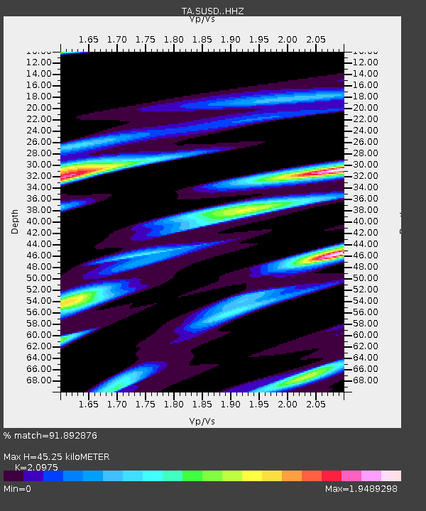
| Estimated Moho Depth: |
45.25 km |
| Estimated Crust Vp/Vs: |
2.10 |
| Assumed Crust Vp: |
6.53 km/s |
| Estimated Crust Vs: |
3.113 km/s |
| Estimated Crust Poisson's Ratio: |
0.35 |
|
| Radial Match: |
91.892876 % |
| Radial Bump: |
287 |
| Transverse Match: |
82.05591 % |
| Transverse Bump: |
400 |
| SOD ConfigId: |
13570011 |
| Insert Time: |
2019-04-28 07:49:46.456 +0000 |
| GWidth: |
2.5 |
| Max Bumps: |
400 |
| Tol: |
0.001 |
|

Signal To Noise
| Channel | StoN | STA | LTA |
| TA:SUSD: :HHZ:20170630T22:37:48.629987Z | 8.696876 | 1.1630223E-6 | 1.3372875E-7 |
| TA:SUSD: :HHN:20170630T22:37:48.629987Z | 7.1675706 | 7.975275E-7 | 1.1126887E-7 |
| TA:SUSD: :HHE:20170630T22:37:48.629987Z | 2.281376 | 2.71985E-7 | 1.1921972E-7 |
| Arrivals |
| Ps | 8.0 SECOND |
| PpPs | 20 SECOND |
| PsPs/PpSs | 28 SECOND |


