You are here: Home > Network List > TA - USArray Transportable Network (new EarthScope stations) Stations List
> Station A05A Maple Falls, WA, USA > Earthquake Result Viewer
A05A Maple Falls, WA, USA - Earthquake Result Viewer

| Earthquake location: |
Western Brazil |
| Earthquake latitude/longitude: |
-8.1/-71.3 |
| Earthquake time(UTC): |
2007/07/21 (202) 13:27:04 GMT |
| Earthquake Depth: |
645 km |
| Earthquake Magnitude: |
6.2 MB, 6.1 MW, 6.0 MW |
| Earthquake Catalog/Contributor: |
WHDF/NEIC |
|
| Network: |
TA USArray Transportable Network (new EarthScope stations) |
| Station: |
A05A Maple Falls, WA, USA |
| Lat/Lon: |
49.00 N/122.09 W |
| Elevation: |
174 m |
|
| Distance: |
72.2 deg |
| Az: |
327.573 deg |
| Baz: |
126.281 deg |
| Ray Param: |
0.051609427 |
| Estimated Moho Depth: |
22.25 km |
| Estimated Crust Vp/Vs: |
1.60 |
| Assumed Crust Vp: |
6.566 km/s |
| Estimated Crust Vs: |
4.104 km/s |
| Estimated Crust Poisson's Ratio: |
0.18 |
|
| Radial Match: |
85.25947 % |
| Radial Bump: |
400 |
| Transverse Match: |
76.70913 % |
| Transverse Bump: |
400 |
| SOD ConfigId: |
2564 |
| Insert Time: |
2010-03-06 01:32:26.864 +0000 |
| GWidth: |
2.5 |
| Max Bumps: |
400 |
| Tol: |
0.001 |
|
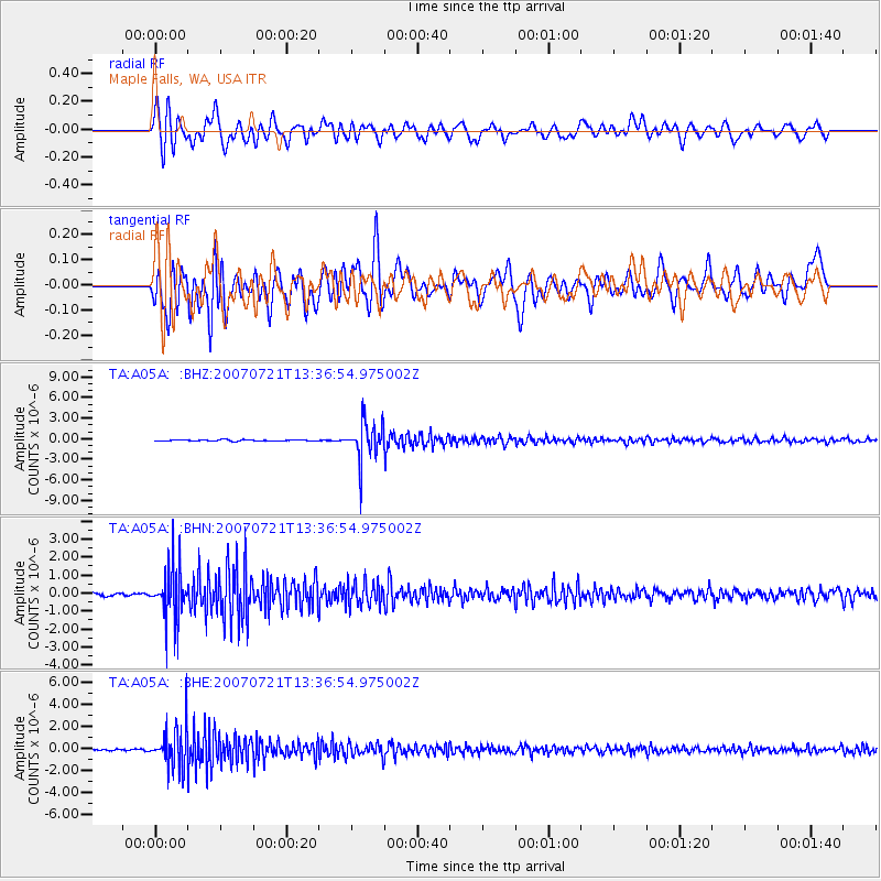
Signal To Noise
| Channel | StoN | STA | LTA |
| TA:A05A: :BHN:20070721T13:36:54.975002Z | 12.132943 | 1.4079283E-6 | 1.1604178E-7 |
| TA:A05A: :BHE:20070721T13:36:54.975002Z | 24.353136 | 1.8722618E-6 | 7.68797E-8 |
| TA:A05A: :BHZ:20070721T13:36:54.975002Z | 28.834217 | 2.6570665E-6 | 9.214977E-8 |
| Arrivals |
| Ps | 2.1 SECOND |
| PpPs | 8.5 SECOND |
| PsPs/PpSs | 11 SECOND |


