You are here: Home > Network List > TX - Texas Seismological Network Stations List
> Station FW06 Azle > Earthquake Result Viewer
FW06 Azle - Earthquake Result Viewer
| Earthquake location: |
Near Coast Of Ecuador |
| Earthquake latitude/longitude: |
-0.3/-80.5 |
| Earthquake time(UTC): |
2017/06/30 (181) 22:29:44 GMT |
| Earthquake Depth: |
7.4 km |
| Earthquake Magnitude: |
6.0 Mww |
| Earthquake Catalog/Contributor: |
NEIC PDE/us |
|
| Network: |
TX Texas Seismological Network |
| Station: |
FW06 Azle |
| Lat/Lon: |
32.97 N/97.56 W |
| Elevation: |
233 m |
|
| Distance: |
36.8 deg |
| Az: |
335.716 deg |
| Baz: |
150.71 deg |
| Ray Param: |
0.07647817 |
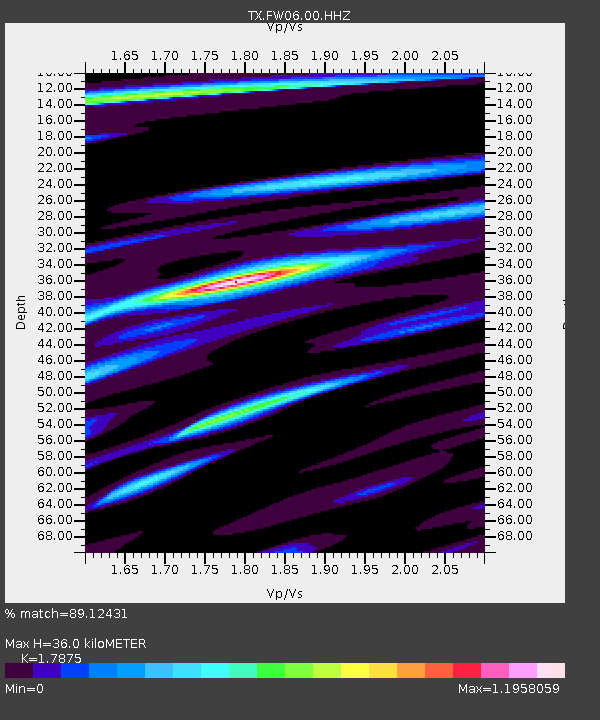
| Estimated Moho Depth: |
36.0 km |
| Estimated Crust Vp/Vs: |
1.79 |
| Assumed Crust Vp: |
6.38 km/s |
| Estimated Crust Vs: |
3.57 km/s |
| Estimated Crust Poisson's Ratio: |
0.27 |
|
| Radial Match: |
89.12431 % |
| Radial Bump: |
342 |
| Transverse Match: |
66.58958 % |
| Transverse Bump: |
400 |
| SOD ConfigId: |
13570011 |
| Insert Time: |
2019-04-28 07:49:59.471 +0000 |
| GWidth: |
2.5 |
| Max Bumps: |
400 |
| Tol: |
0.001 |
|

Signal To Noise
| Channel | StoN | STA | LTA |
| TX:FW06:00:HHZ:20170630T22:36:21.609998Z | 5.121109 | 4.3699993E-7 | 8.533307E-8 |
| TX:FW06:00:HH1:20170630T22:36:21.609998Z | 3.2562273 | 2.766509E-7 | 8.4960554E-8 |
| TX:FW06:00:HH2:20170630T22:36:21.609998Z | 1.2505217 | 1.835475E-7 | 1.4677674E-7 |
| Arrivals |
| Ps | 4.8 SECOND |
| PpPs | 15 SECOND |
| PsPs/PpSs | 19 SECOND |


