You are here: Home > Network List > TA - USArray Transportable Network (new EarthScope stations) Stations List
> Station A05A Maple Falls, WA, USA > Earthquake Result Viewer
A05A Maple Falls, WA, USA - Earthquake Result Viewer
| Earthquake location: |
Sichuan, China |
| Earthquake latitude/longitude: |
31.0/103.3 |
| Earthquake time(UTC): |
2008/05/12 (133) 06:28:01 GMT |
| Earthquake Depth: |
19 km |
| Earthquake Magnitude: |
6.9 MB, 8.1 MS, 7.9 MW, 7.9 MW |
| Earthquake Catalog/Contributor: |
WHDF/NEIC |
|
| Network: |
TA USArray Transportable Network (new EarthScope stations) |
| Station: |
A05A Maple Falls, WA, USA |
| Lat/Lon: |
49.00 N/122.09 W |
| Elevation: |
174 m |
|
| Distance: |
90.7 deg |
| Az: |
27.971 deg |
| Baz: |
322.301 deg |
| Ray Param: |
0.041656803 |
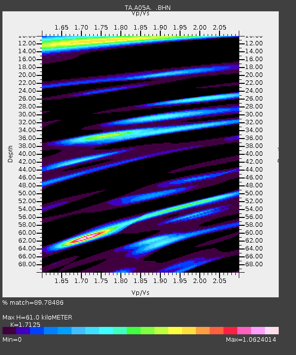
| Estimated Moho Depth: |
61.0 km |
| Estimated Crust Vp/Vs: |
1.71 |
| Assumed Crust Vp: |
6.566 km/s |
| Estimated Crust Vs: |
3.834 km/s |
| Estimated Crust Poisson's Ratio: |
0.24 |
|
| Radial Match: |
89.78486 % |
| Radial Bump: |
400 |
| Transverse Match: |
83.64172 % |
| Transverse Bump: |
400 |
| SOD ConfigId: |
2504 |
| Insert Time: |
2010-03-06 01:32:45.805 +0000 |
| GWidth: |
2.5 |
| Max Bumps: |
400 |
| Tol: |
0.001 |
|
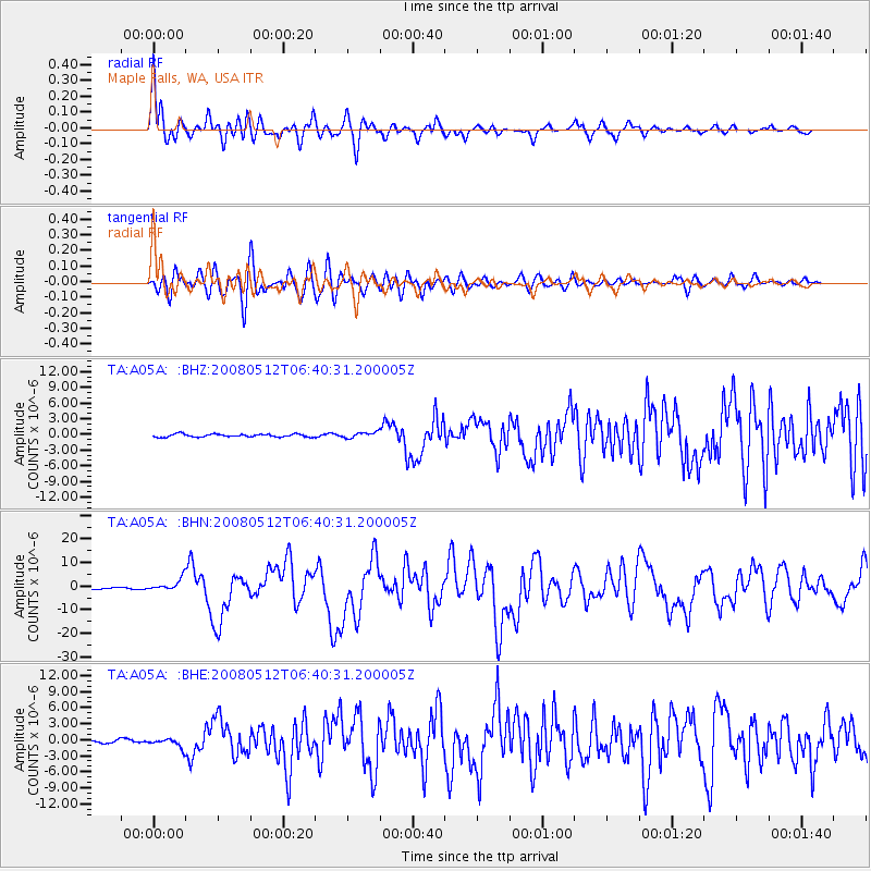
Signal To Noise
| Channel | StoN | STA | LTA |
| TA:A05A: :BHN:20080512T06:40:31.200005Z | 7.563124 | 2.6365053E-6 | 3.4860005E-7 |
| TA:A05A: :BHE:20080512T06:40:31.200005Z | 3.4751155 | 8.345751E-7 | 2.401575E-7 |
| TA:A05A: :BHZ:20080512T06:40:31.200005Z | 1.9313068 | 5.3717525E-7 | 2.781408E-7 |
| Arrivals |
| Ps | 6.8 SECOND |
| PpPs | 25 SECOND |
| PsPs/PpSs | 31 SECOND |


