You are here: Home > Network List > TA - USArray Transportable Network (new EarthScope stations) Stations List
> Station A05A Maple Falls, WA, USA > Earthquake Result Viewer
A05A Maple Falls, WA, USA - Earthquake Result Viewer
| Earthquake location: |
Peru-Brazil Border Region |
| Earthquake latitude/longitude: |
-7.6/-74.4 |
| Earthquake time(UTC): |
2008/08/26 (239) 21:00:36 GMT |
| Earthquake Depth: |
154 km |
| Earthquake Magnitude: |
6.0 MB, 6.4 MW, 6.4 MW |
| Earthquake Catalog/Contributor: |
WHDF/NEIC |
|
| Network: |
TA USArray Transportable Network (new EarthScope stations) |
| Station: |
A05A Maple Falls, WA, USA |
| Lat/Lon: |
49.00 N/122.09 W |
| Elevation: |
174 m |
|
| Distance: |
70.1 deg |
| Az: |
328.801 deg |
| Baz: |
128.77 deg |
| Ray Param: |
0.054771606 |
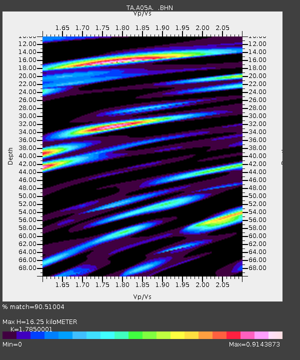
| Estimated Moho Depth: |
16.25 km |
| Estimated Crust Vp/Vs: |
1.79 |
| Assumed Crust Vp: |
6.566 km/s |
| Estimated Crust Vs: |
3.679 km/s |
| Estimated Crust Poisson's Ratio: |
0.27 |
|
| Radial Match: |
90.51004 % |
| Radial Bump: |
400 |
| Transverse Match: |
84.62305 % |
| Transverse Bump: |
400 |
| SOD ConfigId: |
2504 |
| Insert Time: |
2010-03-06 01:32:59.429 +0000 |
| GWidth: |
2.5 |
| Max Bumps: |
400 |
| Tol: |
0.001 |
|

Signal To Noise
| Channel | StoN | STA | LTA |
| TA:A05A: :BHN:20080826T21:11:01.399001Z | 25.189327 | 2.9503935E-6 | 1.17128714E-7 |
| TA:A05A: :BHE:20080826T21:11:01.399001Z | 6.8610196 | 1.0279981E-6 | 1.4983168E-7 |
| TA:A05A: :BHZ:20080826T21:11:01.399001Z | 8.161179 | 9.303843E-7 | 1.1400122E-7 |
| Arrivals |
| Ps | 2.0 SECOND |
| PpPs | 6.6 SECOND |
| PsPs/PpSs | 8.7 SECOND |


