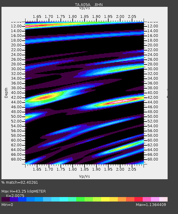
A05A Maple Falls, WA, USA - Earthquake Result Viewer

Earthquake location: Kermadec Islands, New Zealand
Earthquake latitude/longitude: -29.8/-177.7
Earthquake time(UTC): 2008/09/29 (273) 15:19:31 GMT
Earthquake Depth: 36 km
Earthquake Magnitude: 6.5 MB, 6.7 MS, 7.0 MW, 7.0 MW
Earthquake Catalog/Contributor: WHDF/NEIC
Network: TA USArray Transportable Network (new EarthScope stations)
Station: A05A Maple Falls, WA, USA
Lat/Lon: 49.00 N/122.09 W
Elevation: 174 m
Distance: 92.8 deg
Az: 32.958 deg
Baz: 225.915 deg
Ray Param: 0.041383818
Estimated Moho Depth: 43.25 km
Estimated Crust Vp/Vs: 2.01
Assumed Crust Vp: 6.566 km/s
Estimated Crust Vs: 3.271 km/s
Estimated Crust Poisson's Ratio: 0.33
Radial Match: 82.40261 %
Radial Bump: 400
Transverse Match: 80.25151 %
Transverse Bump: 400
SOD ConfigId: 2560
Insert Time: 2010-03-06 01:33:08.962 +0000
GWidth: 2.5
Max Bumps: 400
Tol: 0.001

Signal To Noise

ChannelStoNSTALTA
TA:A05A: :BHN:20080929T15:32:08.800022Z8.690876.9530813E-78.000443E-8
TA:A05A: :BHE:20080929T15:32:08.800022Z1.19925959.234527E-87.700191E-8
TA:A05A: :BHZ:20080929T15:32:08.800022Z2.27174541.7168524E-77.557416E-8
Arrivals
Ps6.8 SECOND
PpPs19 SECOND
PsPs/PpSs26 SECOND