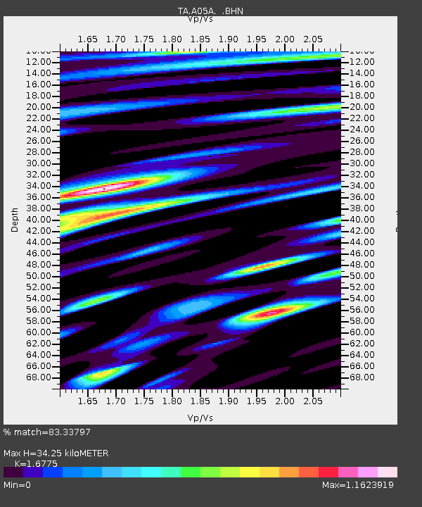
A05A Maple Falls, WA, USA - Earthquake Result Viewer
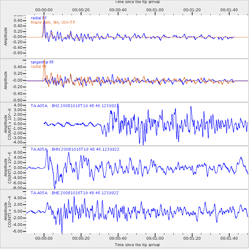
Earthquake location: Near Coast Of Chiapas, Mexico
Earthquake latitude/longitude: 14.4/-92.4
Earthquake time(UTC): 2008/10/16 (290) 19:41:25 GMT
Earthquake Depth: 24 km
Earthquake Magnitude: 6.1 MB, 6.6 MS, 6.7 MW, 6.6 MW
Earthquake Catalog/Contributor: WHDF/NEIC
Network: TA USArray Transportable Network (new EarthScope stations)
Station: A05A Maple Falls, WA, USA
Lat/Lon: 49.00 N/122.09 W
Elevation: 174 m
Distance: 42.2 deg
Az: 330.937 deg
Baz: 134.386 deg
Ray Param: 0.073256426
Estimated Moho Depth: 34.25 km
Estimated Crust Vp/Vs: 1.68
Assumed Crust Vp: 6.566 km/s
Estimated Crust Vs: 3.914 km/s
Estimated Crust Poisson's Ratio: 0.22
Radial Match: 83.33797 %
Radial Bump: 400
Transverse Match: 76.760056 %
Transverse Bump: 400
SOD ConfigId: 2560
Insert Time: 2010-03-06 01:33:12.856 +0000
GWidth: 2.5
Max Bumps: 400
Tol: 0.001

Signal To Noise

ChannelStoNSTALTA
TA:A05A: :BHN:20081016T19:48:46.123992Z11.3825052.956208E-62.5971505E-7
TA:A05A: :BHE:20081016T19:48:46.123992Z5.32925751.2178707E-62.2852538E-7
TA:A05A: :BHZ:20081016T19:48:46.123992Z5.0412711.1217047E-62.2250433E-7
Arrivals
Ps3.8 SECOND
PpPs13 SECOND
PsPs/PpSs17 SECOND