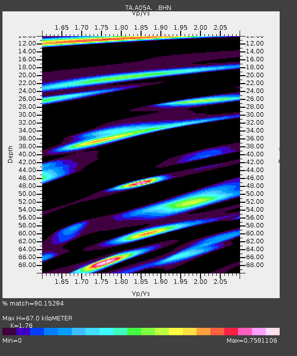
A05A Maple Falls, WA, USA - Earthquake Result Viewer
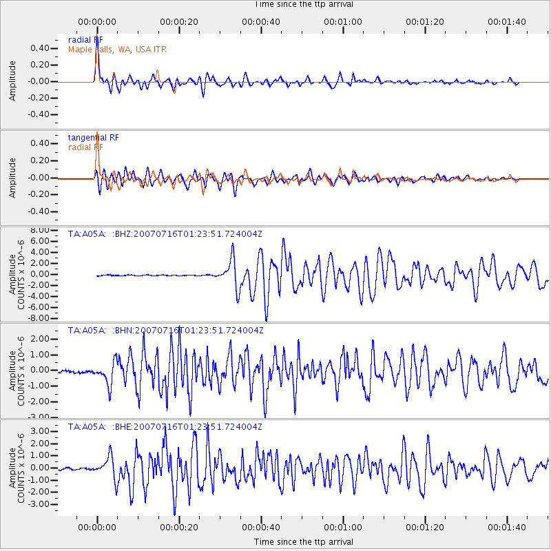
Earthquake location: Near West Coast Of Honshu, Japan
Earthquake latitude/longitude: 37.5/138.4
Earthquake time(UTC): 2007/07/16 (197) 01:13:22 GMT
Earthquake Depth: 12 km
Earthquake Magnitude: 6.5 MB, 6.4 MS, 6.6 MW, 6.5 MW
Earthquake Catalog/Contributor: WHDF/NEIC
Network: TA USArray Transportable Network (new EarthScope stations)
Station: A05A Maple Falls, WA, USA
Lat/Lon: 49.00 N/122.09 W
Elevation: 174 m
Distance: 68.3 deg
Az: 44.375 deg
Baz: 302.418 deg
Ray Param: 0.056416117
Estimated Moho Depth: 67.0 km
Estimated Crust Vp/Vs: 1.76
Assumed Crust Vp: 6.566 km/s
Estimated Crust Vs: 3.731 km/s
Estimated Crust Poisson's Ratio: 0.26
Radial Match: 90.15294 %
Radial Bump: 400
Transverse Match: 81.1339 %
Transverse Bump: 400
SOD ConfigId: 2564
Insert Time: 2010-03-06 01:33:48.982 +0000
GWidth: 2.5
Max Bumps: 400
Tol: 0.001

Signal To Noise

ChannelStoNSTALTA
TA:A05A: :BHN:20070716T01:23:51.724004Z10.5527467.270727E-76.889891E-8
TA:A05A: :BHE:20070716T01:23:51.724004Z15.1598259.359197E-76.1736834E-8
TA:A05A: :BHZ:20070716T01:23:51.724004Z38.7214362.67201E-66.900596E-8
Arrivals
Ps8.1 SECOND
PpPs27 SECOND
PsPs/PpSs35 SECOND