You are here: Home > Network List > G - GEOSCOPE Stations List
> Station ATD Arta Cave - Arta, Republic of Djibouti > Earthquake Result Viewer
ATD Arta Cave - Arta, Republic of Djibouti - Earthquake Result Viewer
| Earthquake location: |
Myanmar-India Border Region |
| Earthquake latitude/longitude: |
24.8/93.7 |
| Earthquake time(UTC): |
2016/01/03 (003) 23:05:22 GMT |
| Earthquake Depth: |
55 km |
| Earthquake Magnitude: |
6.7 MWW, 6.6 MWB |
| Earthquake Catalog/Contributor: |
NEIC PDE/NEIC COMCAT |
|
| Network: |
G GEOSCOPE |
| Station: |
ATD Arta Cave - Arta, Republic of Djibouti |
| Lat/Lon: |
11.53 N/42.85 E |
| Elevation: |
610 m |
|
| Distance: |
49.8 deg |
| Az: |
264.121 deg |
| Baz: |
67.249 deg |
| Ray Param: |
0.068335935 |
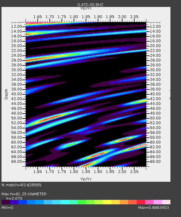
| Estimated Moho Depth: |
61.25 km |
| Estimated Crust Vp/Vs: |
2.08 |
| Assumed Crust Vp: |
6.375 km/s |
| Estimated Crust Vs: |
3.072 km/s |
| Estimated Crust Poisson's Ratio: |
0.35 |
|
| Radial Match: |
93.629585 % |
| Radial Bump: |
400 |
| Transverse Match: |
87.00448 % |
| Transverse Bump: |
400 |
| SOD ConfigId: |
1379111 |
| Insert Time: |
2016-01-17 23:12:11.825 +0000 |
| GWidth: |
2.5 |
| Max Bumps: |
400 |
| Tol: |
0.001 |
|
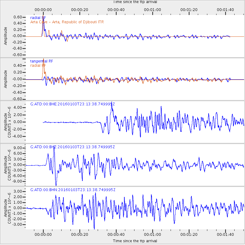
Signal To Noise
| Channel | StoN | STA | LTA |
| G:ATD:00:BHZ:20160103T23:13:38.749995Z | 42.006702 | 2.487834E-6 | 5.922469E-8 |
| G:ATD:00:BHN:20160103T23:13:38.749995Z | 9.239672 | 5.2809867E-7 | 5.7155564E-8 |
| G:ATD:00:BHE:20160103T23:13:38.749995Z | 22.479454 | 1.1920921E-6 | 5.3030295E-8 |
| Arrivals |
| Ps | 11 SECOND |
| PpPs | 28 SECOND |
| PsPs/PpSs | 39 SECOND |


