You are here: Home > Network List > TA - USArray Transportable Network (new EarthScope stations) Stations List
> Station A05A Maple Falls, WA, USA > Earthquake Result Viewer
A05A Maple Falls, WA, USA - Earthquake Result Viewer
| Earthquake location: |
Chile-Argentina Border Region |
| Earthquake latitude/longitude: |
-24.4/-67.0 |
| Earthquake time(UTC): |
2006/08/25 (237) 00:44:46 GMT |
| Earthquake Depth: |
184 km |
| Earthquake Magnitude: |
5.9 MB, 6.6 MW, 6.6 MW |
| Earthquake Catalog/Contributor: |
WHDF/NEIC |
|
| Network: |
TA USArray Transportable Network (new EarthScope stations) |
| Station: |
A05A Maple Falls, WA, USA |
| Lat/Lon: |
49.00 N/122.09 W |
| Elevation: |
174 m |
|
| Distance: |
88.0 deg |
| Az: |
327.304 deg |
| Baz: |
131.601 deg |
| Ray Param: |
0.04247883 |
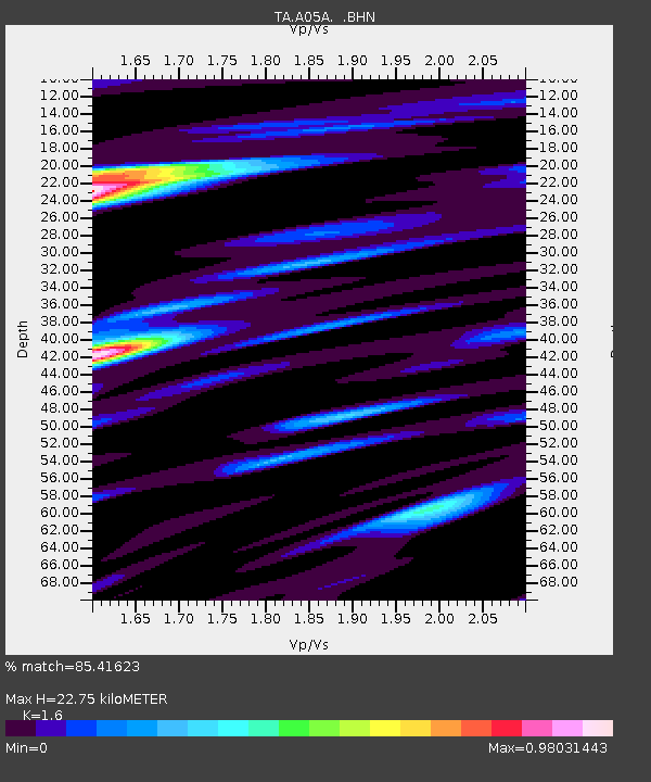
| Estimated Moho Depth: |
22.75 km |
| Estimated Crust Vp/Vs: |
1.60 |
| Assumed Crust Vp: |
6.566 km/s |
| Estimated Crust Vs: |
4.104 km/s |
| Estimated Crust Poisson's Ratio: |
0.18 |
|
| Radial Match: |
85.41623 % |
| Radial Bump: |
400 |
| Transverse Match: |
79.23526 % |
| Transverse Bump: |
400 |
| SOD ConfigId: |
2665 |
| Insert Time: |
2010-03-06 01:34:04.175 +0000 |
| GWidth: |
2.5 |
| Max Bumps: |
400 |
| Tol: |
0.001 |
|

Signal To Noise
| Channel | StoN | STA | LTA |
| TA:A05A: :BHN:20060825T00:56:44.125007Z | 12.936601 | 9.3359586E-7 | 7.216702E-8 |
| TA:A05A: :BHE:20060825T00:56:44.125007Z | 12.357895 | 9.2172354E-7 | 7.4585806E-8 |
| TA:A05A: :BHZ:20060825T00:56:44.125007Z | 23.95947 | 2.4050064E-6 | 1.0037812E-7 |
| Arrivals |
| Ps | 2.1 SECOND |
| PpPs | 8.8 SECOND |
| PsPs/PpSs | 11 SECOND |


