You are here: Home > Network List > TA - USArray Transportable Network (new EarthScope stations) Stations List
> Station O17K Koliganek, Bristol Bay, AK, USA > Earthquake Result Viewer
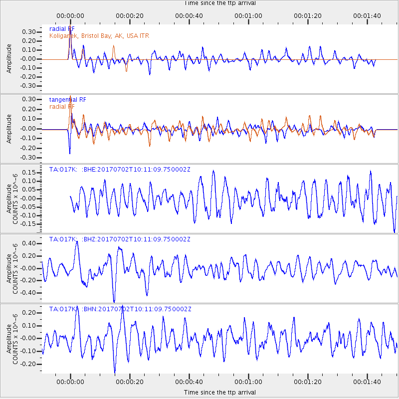
O17K Koliganek, Bristol Bay, AK, USA - Earthquake Result Viewer
*The percent match for this event was below the threshold and hence no stack was calculated.
| Earthquake location: |
Kermadec Islands Region |
| Earthquake latitude/longitude: |
-27.4/-176.5 |
| Earthquake time(UTC): |
2017/07/02 (183) 09:58:50 GMT |
| Earthquake Depth: |
16 km |
| Earthquake Magnitude: |
5.7 Mww |
| Earthquake Catalog/Contributor: |
NEIC PDE/us |
|
| Network: |
TA USArray Transportable Network (new EarthScope stations) |
| Station: |
O17K Koliganek, Bristol Bay, AK, USA |
| Lat/Lon: |
59.77 N/157.09 W |
| Elevation: |
156 m |
|
| Distance: |
88.3 deg |
| Az: |
9.658 deg |
| Baz: |
197.154 deg |
| Ray Param: |
$rayparam |
*The percent match for this event was below the threshold and hence was not used in the summary stack. |
|
| Radial Match: |
61.01413 % |
| Radial Bump: |
400 |
| Transverse Match: |
51.836334 % |
| Transverse Bump: |
400 |
| SOD ConfigId: |
13570011 |
| Insert Time: |
2019-04-28 07:57:17.353 +0000 |
| GWidth: |
2.5 |
| Max Bumps: |
400 |
| Tol: |
0.001 |
|
Signal To Noise
| Channel | StoN | STA | LTA |
| TA:O17K: :BHZ:20170702T10:11:09.750002Z | 2.5452669 | 2.1973044E-7 | 8.6329045E-8 |
| TA:O17K: :BHN:20170702T10:11:09.750002Z | 2.0604668 | 1.27686E-7 | 6.196945E-8 |
| TA:O17K: :BHE:20170702T10:11:09.750002Z | 0.50925267 | 2.8000605E-8 | 5.4983715E-8 |
| Arrivals |
| Ps | |
| PpPs | |
| PsPs/PpSs | |


